A Great Explanation Of The Severe Weather Threat For Today Through Thursday Morning
From the NWS Birmingham Facebook page…
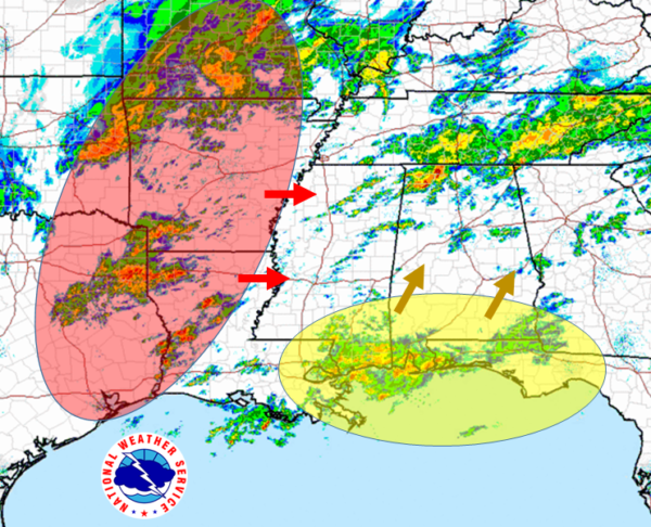
What’s with the wide time window? Let’s look…
There will basically be two “waves” of storms today through tomorrow. The first, highlighted in yellow, is a scattered area of storms moving roughly northeast. This will be the main cause of severe weather this afternoon and early evening. The second “wave” highlighted in red, is closer to the front and will be moving through overnight into the morning Thursday. The area in red has scattered storms showing on radar, but all of these storms are expected to merge into a line feature sometime right before entering Alabama. This is what will cause the main focus of severe weather through the overnight hours.
To add to this explanation, a big uncertainty is how quickly that area in red will move through. If it moves quickly, the atmosphere may not have time to recover from the first wave (remember, the one in yellow), and we may not see quite as much severe weather. If it moves slowly, the atmosphere will have time to gather more energy, and we may have a greater severe weather threat.
Category: Alabama's Weather, ALL POSTS, Severe Weather
About the Author (Author Profile)
Scott Martin is an operational meteorologist, professional graphic artist, musician, husband, and father. Not only is Scott a member of the National Weather Association, but he is also the Central Alabama Chapter of the NWA president. Scott is also the co-founder of Racecast Weather, which provides forecasts for many racing series across the USA. He also supplies forecasts for the BassMaster Elite Series events including the BassMaster Classic.Subscribe
If you enjoyed this article, subscribe to receive more just like it.


