A Brief Check On Our Weather Situation Before 7:00 PM
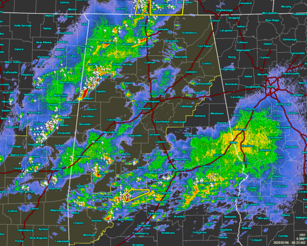
As of 6:33 pm, there are no severe warnings in effect for anyone in North/Central Alabama… but we do have a line of strong thunderstorms pushing through the northwestern corner of the area that is producing very heavy rainfall, gusty winds, and dangerous cloud-to-ground lightning. We have also had reports of some small hail falling in these storms.
Stronger storms were currently affecting parts of Marion, Fayette, and Lamar counties in Central Alabama, along with parts of Madison, Lauderdale, Limestone, Colbert, Franklin, Morgan, and Lawrence counties in North Alabama.
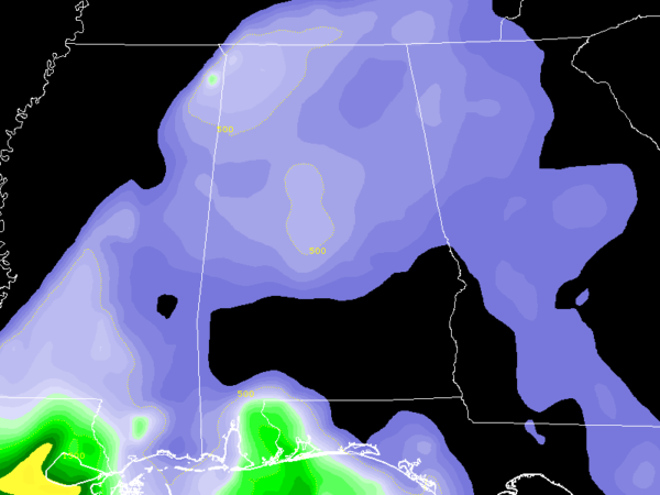
Instability has dropped a little since sunset as we are only seeing CAPE values in the 100-500 J/kg range for the most part, with a small part of the northwest corner with a little higher values possibly reaching 700 J/kg. That is still sufficient enough for stronger storms.
Wind shear continues to be rather strong in the 60-70 knot range… still well more than sufficient to support severe storms and supercells. We’ll need to continue to watch for any rotational signatures on radar as the environment is still primed for the potential of damaging winds up to and exceeding 70 MPH and a few tornadoes. We still can’t rule out a stronger tornado as well.
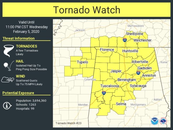
A TORNADO WATCH continues in effect for all of North Alabama and a good chunk of Central Alabama until 11:00 pm tonight. A new watch will probably be needed after that as the second wave of storms is expected to move in around midnight with the cold front that will once again bring the potential of damaging winds and a brief tornado or two.
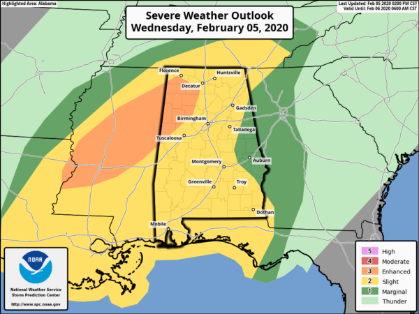
We continue to have an Enhanced Risk (level 3 of 5) in effect for a good portion of the northwestern parts of North/Central Alabama through the rest of tonight and into the morning hours on Thursday. Nearly the rest of North/Central Alabama remains in a Slight Risk (level 2 of 5).
That time window for strong to severe storms will be from now through 2:00 am Thursday morning for the western parts of the area, 5:00 pm this evening to 4:00 am Thursday for the central parts of the area (I-65 and I-59 corridors), and 7:00 pm this evening through 10:00 am Thursday morning for the extreme eastern and southeastern parts of the area.
We’ll continue to have updates through the night and in the morning.
Category: Alabama's Weather, ALL POSTS, Severe Weather
About the Author (Author Profile)
Scott Martin is an operational meteorologist, professional graphic artist, musician, husband, and father. Not only is Scott a member of the National Weather Association, but he is also the Central Alabama Chapter of the NWA president. Scott is also the co-founder of Racecast Weather, which provides forecasts for many racing series across the USA. He also supplies forecasts for the BassMaster Elite Series events including the BassMaster Classic.Subscribe
If you enjoyed this article, subscribe to receive more just like it.


