Noon Update: Beautiful Day in Progress; More Flooding and Severe Weather in our Future
I thought I would take time out from my current construction project to update you on the weather. It was an appropriate stopping point since I am waiting on another shipment of Gopher Wood to come from the local lumber yard. But I’d better hurry because I fear we will need this yacht by tomorrow night.
ALABAMA AT NOON: All the dense fog that formed overnight has burned off late this morning. The bright blue February sky features a few clouds that are serving to give it character early this afternoon. Thermometers were busily climbing through the 50s. Highs will top out in the lower and middle 60s across North Central Alabama, with middle and upper 60s to the south. Demopolis may actually flirt with 70F later today. Clouds will start to increase overnight. Lows will be in the upper 40s to lower 50s. A few showers could light up local radars this evening, but it will be after midnight when the main rainfall will encroach on the northwestern corner of the state.
RAIN RETURNS. An approaching trough, rapidly increasing moisture, and increasing wind speeds aloft will lead to higher rain chances as we go through the overnight tonight and into Monday. It may be mid to late morning before the rainfall reaches the I-59 Corridor, but once it does, the rain will settle in for a bit. Heavy rain and will move across areas generally north of I-20 late Monday afternoon and Monday evening.
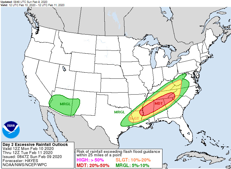
MODERATE RISK – FOR FLOODING: The WPC issues excessive rainfall outlooks, like the SPC does for severe weather. They have outlooked northern and North Central Alabama in a moderate risk for flash flooding for Monday and Monday night. A flood watch is in effect for Monday through Tuesday across the I-20 Corridor and points north. By Tuesday morning, rainfall totals may reach 5 or more inches in a stripe across North Central Alabama, with 1-3 inch amounts on either side. There could be a little thunder involved.
MARGINAL RISK MONDAY NIGHT: In fact, the SPC has outlooked western Alabama for a marginal threat of severe weather Monday evening and overnight. A few showers and storms will continue through Tuesday, but most of the day will be dry.
NEXT ROUND: By Wednesday morning, a surface low will be tracking through the Great Lakes with a trailing cold front back into the Arklatex. This setup will push another round of rain and storms. Severe weather will be a threat. The SPC is projecting out that there will be a slight risk with this event Wednesday evening. Another line of strong to severe storms will push into Alabama Wednesday night, bringing a chance of damaging winds, hail, and possibly tornadoes. As with the last severe weather system, instabilities will be fairly low, but wind shear will be strong. The surface low will be fairly far away, so perhaps that tornado threat will be limited. But we will have to keep an eye on it.
Category: Alabama's Weather, ALL POSTS
About the Author (Author Profile)
Bill Murray is the President of The Weather Factory. He is the site's official weather historian and a weekend forecaster. He also anchors the site's severe weather coverage. Bill Murray is the proud holder of National Weather Association Digital Seal #0001 @wxhistorianSubscribe
If you enjoyed this article, subscribe to receive more just like it.


