Heavy Rain & Thunderstorms Expected To Train Over The Same Areas For The Next Several Hours
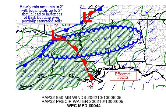
The latest Mesoscale Precipitation Discussion was just released from the NWS Weather Prediction Center that included a good portion of North/Central Alabama. Training cells of heavy rain and thunderstorms are expected to continue to move over the same areas over the next several hours, dropping as much as 2.00 inches of rain, with some localized amounts potentially reaching the 3.00-5.00 inch range. Here is the discussion from the WPC:
In-Depth Discussion From The WPC: A wave of low pressure near the ArkLaTex along with a weak warm front across the Lower Mississippi Valley are acting as the foci for overrunning showers and thunderstorms with slowly increasing rainfall amounts; CIN is forcing a good amount of the convection to be elevated over the warm front. MU CAPE of 500-1500 J/kg exists across LA, southern AR, and MS per SPC mesoanalyses. Inflow at 850 hPa is convergent out of the southwest at 30-50 kts per VAD wind profiles. The mean 850-400 hPa wind is out of the west-southwest at similar magnitude, with the 1000-500 hPa thickness lines beginning to align with the mean flow. Precipitable water values in the area are 1.3-1.7″ per GPS data. Storms with some structure (an occasional mesocyclone) along with a general increase in cell coverage have led to some increase in the hourly totals across LA and MS per WSR-88D imagery, with local hourly amounts of 1″+ in several spots and 2″ east of Olla, LA.
The expectation is for the warm front to shift eastward with time which would allow rainfall in areas farther east in eastern MS and AL to become more convective as MUCAPE/MLCAPE increase. GFS-based Galvez-Davison Index values imply slowly increasing convective coverage with time today across this region. Slowly veering 850 hPa flow will become more aligned with the mean flow, which also would increase the potential for heavy rainfall. But, the axis of 850 hPa convergence is expected to shift somewhat, which should limit rainfall magnitude. Hourly totals of 1-2″ are expected where thunderstorms happen to train within this quick flow pattern, with the 06z HREF probabilities of 1″+ highest through 18z before slowly fading thereafter. While a bulk of the mesoscale guidance forecasts local amounts of 2-4″ in this region, the 00z WRF NSSL (5″) and the 12z NAM CONEST (7″) indicating higher potential. Think local amounts in the 3-5″ range are possible here. Two week and one-month precipitation anomalies are generally 1-2 times average, leading to soils which are partially saturated which is reflected in the flash flood guidance values. Flash flooding is considered likely.
Category: Alabama's Weather, ALL POSTS
About the Author (Author Profile)
Scott Martin is an operational meteorologist, professional graphic artist, musician, husband, and father. Not only is Scott a member of the National Weather Association, but he is also the Central Alabama Chapter of the NWA president. Scott is also the co-founder of Racecast Weather, which provides forecasts for many racing series across the USA. He also supplies forecasts for the BassMaster Elite Series events including the BassMaster Classic.Subscribe
If you enjoyed this article, subscribe to receive more just like it.


