

More Heavy Rains Developing to the West, Will Affect Parts of the Area Next Few Hours
Rainfall has really increased tonight across the northern half of Mississippi ahead of a surface low moving that extends from northeastern Louisiana into western Mississippi. An increasing low level jeet will transport lots of extremely moist air northward overnight, enhancing the rainfall.
Areas northwest of I-20 look to have the best chances for excessive rainfall through the overnight hours as the large area of rain shifts eastward and lifts northward.
Additional amounts of 1-2 inches will be likely over the next few hours. Falling on already saturated ground, this rainfall will cause additional flooding.
Flood warnings continue for all of the I-20 Corridor tonight. Current warnings include:
…Flood Warning for Bibb, Greene, Jefferson, Pickens, Shelby, Sumter, Tuscaloosa [AL] till Feb 11, 12:15 AM CST. There are numerous reports of flooding across this area.
…Flood Warning for Calhoun, Clay, Cleburne, Coosa, Randolph, St. Clair, Talladega [AL] till Feb 11, 2:30 AM CST. Numerous reports of flooding in the city of Anniston and across the warning area.
…Flood Warning for Bibb, Chilton, Hale, Perry [AL] till Feb 11, 2:30 AM CST.
…Flood Warning for Colbert, Cullman, DeKalb, Franklin, Jackson, Lauderdale, Lawrence, Limestone, Madison, Marshall, and Morgan till 5:00 AM CST
In addition, a Flash Flood Watch continues for Bibb, Blount, Calhoun, Cherokee, Clay, Cleburne, Etowah, Fayette, Greene, Hale, Jefferson, Lamar, Marion, Pickens, Randolph, Shelby, St. Clair, Sumter, Talladega, Tuscaloosa, Walker, Winston [AL] till Feb 11, 6:00 PM CST
Here is the text of the WPC Mesoscale Discussion:
Mesoscale Precipitation Discussion 0047
NWS Weather Prediction Center College Park MD
954 PM EST Mon Feb 10 2020
Areas affected…Portions of LA/AR/MS/AL
Concerning…Heavy rainfall…Flash flooding likely
Valid 110254Z – 110854Z
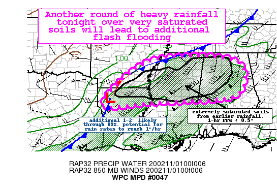
Summary…Another round of heavy rainfall through the overnight
hours falling on very saturated soils will renew flash flooding in
the area. Some significant flash flooding is possible with
additional totals of 1-2″ through 09Z.
Discussion…Widespread moderate to locally heavy rainfall
continues to fall across portions of the Deep South this evening.
A surface analysis at 02Z showed an area of low pressure over
northwest LA with an associated stationary boundary draped
northeastward into portions of MS. Regional radar and IR satellite
imagery indicate that convection has begun to intensify per
instantaneous radar estimates eclipsing 1.5″/hr across
northern/northeast LA and rapidly cooling cloud tops.
The environment in the outlook area is characterized by highly
anomalous PWs (11.00Z obs 1.63″ at JAN and 1.64″ at LCH would be
daily records per SPC sounding climatology) and moderate amounts
of instability (~1000 J/kg MUCAPE). The low-level jet is forecast
to ramp up this evening, from around 30 kts to over 50 kts toward
06Z, and this increase combined with the stalled/stationary
boundary in the area should focus additional heavy rainfall in a
southwest to northeast swath. The storm motions are nearly
parallel to the expected overall mean flow (southwesterly) and
this will favor repeating rounds and training.
A consensus of the latest hi-res models shows potential for 1-2″
through 09Z with some local amounts approaching 3″ possible. HREF
probabilities of exceeding 0.5″ in 1 hour (around the 1-hr FFG in
most of the outlook area) is high (60-70 percent) for several
hours.
Making the situation worse is the extremely saturated soils in
place. Rainfall in the past 12-18 hours has totaled 2-4″ with some
local reports near 5″ and subsequently the latest FFG is very low
(1-hr FFG as low as 0.5″). The latest NWM streamflows are maxed
out and 40 cm soil saturation is near 100 percent. All of the
additional rainfall tonight will be runoff and this is expected to
initiate or worsen ongoing flooding in the area. If storms align
over areas hardest hit earlier today, some localized significant
flash flooding is possible. The dangers of nighttime flash
flooding are stressed, especially given the ongoing flooding in
the area. The additional rainfall will act to produce flooding in
areas that usually do not flood.
Taylor
Category: Alabama's Weather, ALL POSTS
About the Author (Author Profile)
Bill Murray is the President of The Weather Factory. He is the site's official weather historian and a weekend forecaster. He also anchors the site's severe weather coverage. Bill Murray is the proud holder of National Weather Association Digital Seal #0001 @wxhistorianSubscribe
If you enjoyed this article, subscribe to receive more just like it.


