Rain Continuing To Move Across Central Alabama At Midday
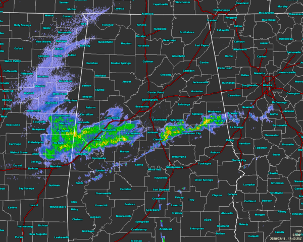
As of 11:42 am, we have a broken horizontal line of showers continuing to move across the south-central parts of Central Alabama. Intensity within the light is mostly moderate but there are a pew embedded heavier downpours occurring. While major flash flooding may not be an issue across the area for the rest of today, some localized minor flooding may occur with this line.
Unfortunately, there is plenty of more showers and a few thunderstorms back to our west that will move into the area later this afternoon and through a good bit of the evening. Those look to mainly affect portions of the area along and north of the I-20/59 and I-20 corridor where the rain is definitely not needed. Throughout the late-night and overnight hours, much of that activity will be moving northward and potentially moving completely into Tennessee by just after midnight. A few isolated showers may be possible over the area prior to dawn. Today’s highs will be in the lower 60s to the upper 70s with lows in the mid-40s to the lower 60s.
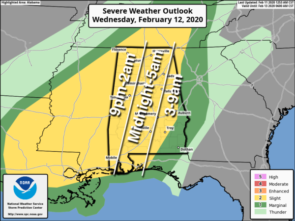
Still, no change in what we are looking at for Wednesday. We may have a few light showers move across Central Alabama during the morning and early afternoon hours, but we’ll have a Slight Risk for severe storms during the evening and overnight hours. Damaging winds up to 60 MPH will be the main threat, but there is a non-zero threat for a brief tornado or two. The main window wiss start around 9:00 pm in the western parts of the area and should be coming to an end in the east around or before 9:00 am. Before the threat, the day will be mostly cloudy and windy with highs reaching the upper 60s to the upper 70s.
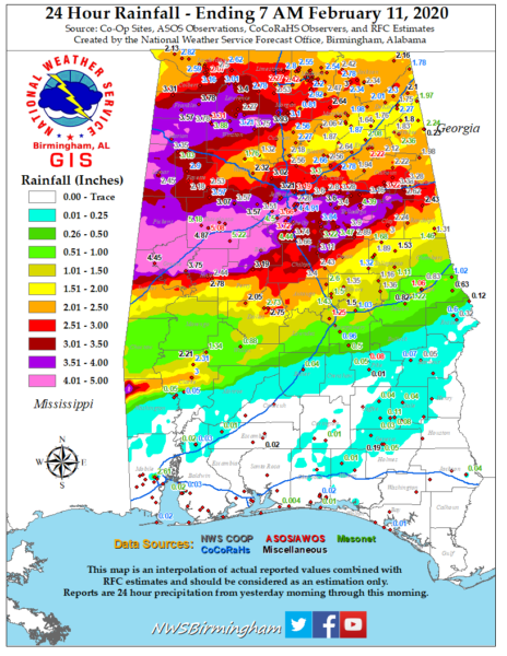
The above image is rainfall totals from yesterday through early this morning. We can see that the extreme southeastern parts of the area had very little rain while some locations in the northern half of the area received over 4.00-5.00 inches. Expected additional rainfall amounts through Thursday evening look to be in the 0.25-2.00 inch range across the area from southeast to northwest. Maybe just enough to cause more flooding issues and more flood watches may be issued later today.
We’ll continue to have updates through the rest of the day. Stay tuned.
Category: Alabama's Weather, ALL POSTS, Severe Weather
About the Author (Author Profile)
Scott Martin is an operational meteorologist, professional graphic artist, musician, husband, and father. Not only is Scott a member of the National Weather Association, but he is also the Central Alabama Chapter of the NWA president. Scott is also the co-founder of Racecast Weather, which provides forecasts for many racing series across the USA. He also supplies forecasts for the BassMaster Elite Series events including the BassMaster Classic.Subscribe
If you enjoyed this article, subscribe to receive more just like it.


