A Brief Morning Check On Our Weather; Severe Storms Possible Later This Evening

As of 9:20 am this morning, we have several spotty showers out there across North/Central Alabama with most of them falling over the extreme northern parts of Central Alabama and the southern parts of North Alabama. Nothing too heavy at this juncture and it looks like that we should stay mostly dry throughout the day with only a few spotty showers moving north-northeastward through the area. A few heavier showers are possible over the northwest corner of the state between late morning and mid-afternoon.
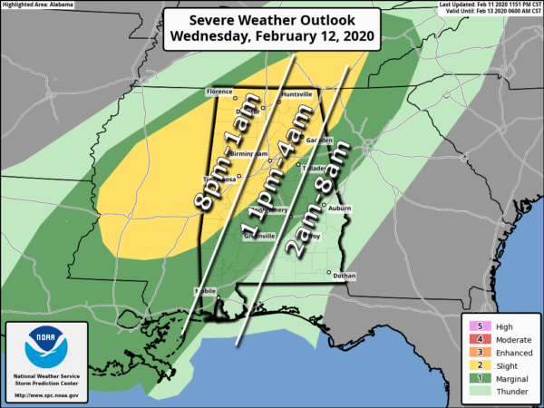
The standard Slight Risk for severe storms is up for the northwestern half of the area, mainly north of a line from Piedmont (Calhoun Co.) to Columbiana (Shelby Co.) to Linden (Marengo Co.). A Marginal Risk is up for locations south of that to a line stretching from Lanett (Chambers Co.) to Franklin (Macon Co.) to just north of Ramer (Montgomery Co.).
We continue to see the threats of damaging winds up to 60 MPH and a brief tornado or two starting around 8:00 pm tonight for the western portions of the area, 11:00 pm for the central portions, and 2:00 Thursday for the eastern portions of North/Central Alabama.
This looks to be a typical winter-type severe event with high wind shear and lower instability. There may be just enough instability with the moist atmosphere that we could see a few stronger cells develop out ahead of the main squall line that we’ll have to keep our eyes on, but the main threat will come as the squall line moves through just ahead of the cold front.
My worries are that with the already saturated soils that we may have plenty of trees downed due to strong winds even without a tornado or winds reaching severe criteria. With winds potentially gusting as high as 30 MPH this afternoon and evening, some of the weaker or dying trees may fall. We may have a few power outages due to that.
We’ll keep you posted through the day and into the night-time and overnight hours.
Category: Alabama's Weather, ALL POSTS, Severe Weather
About the Author (Author Profile)
Scott Martin is an operational meteorologist, professional graphic artist, musician, husband, and father. Not only is Scott a member of the National Weather Association, but he is also the Central Alabama Chapter of the NWA president. Scott is also the co-founder of Racecast Weather, which provides forecasts for many racing series across the USA. He also supplies forecasts for the BassMaster Elite Series events including the BassMaster Classic.Subscribe
If you enjoyed this article, subscribe to receive more just like it.


