Late Morning Update To The Severe Storm/Heavy Rain Event Starting Tonight
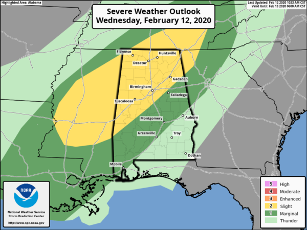
We continue to have the standard Slight Risk for severe storms is up for the northwestern half of the area, mainly north of a line from Piedmont (Calhoun Co.) to Columbiana (Shelby Co.) to Linden (Marengo Co.). A Marginal Risk is up for locations south of that to a line stretching from Lanett (Chambers Co.) to Franklin (Macon Co.) to just north of Ramer (Montgomery Co.).
The main window for stronger to severe storms will be from around 8:00 pm tonight through 9:00 am Thursday morning. The breakdown in sections will be from 8:00 pm to 1:00 am for the western parts, 11:00 pm to 4:00 am for the central parts, and 2:00 am to 9:00 am for the eastern parts of the area.
The line of storms will move into the area tonight will have the higher potential for stronger to severe storms in the Slight Risk locations but it will be in the process of weakening as it approaches the I-65 corridor. Conditions are expected to become less favorable for stronger to severe storms in the eastern parts of the area. Damaging wind gusts up to 60 MPH and a brief tornado or two will be possible across the area, but the threats will be much lower in the Marginal Risk locations.
The setup is not all that impressive at this point with forecast models showing limited instability and just enough sheer to be supportive of stronger to severe storms. The stronger helicity will be mostly northeast of the area as the line moves through. I believe that the main threat that we’ll see tonight will be from the heavy rain, especially if we do have training of those heavier cells over the same locations.
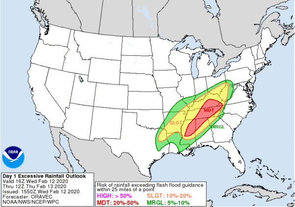
If we do have rain heavy enough to cause flooding issues, this map from the Weather Prediction Center shows the likelihood being along and north of the I-20-59 and I-59 corridor for the northern half of the state. Current forecast models are showing that another 1-2 inches of rainfall will be possible through the day today and ending at 6:00 pm Thursday, with most of that coming with the main line of storms and behind it.
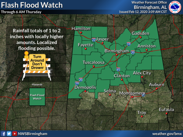
Therefore, NWS Birmingham has a FLASH FLOOD WATCH up through 6:00 pm Thursday for Bibb, Blount, Calhoun, Cherokee, Chilton, Clay, Cleburne, Coosa, Etowah, Fayette, Greene, Hale, Jefferson, Lamar, Marion, Perry, Pickens, Randolph, Shelby, St. Clair, Sumter, Talladega, Tuscaloosa, Walker, and Winston counties in Central Alabama.
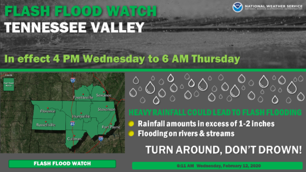
NWS Huntsville also has a FLASH FLOOD WATCH up through 6:00 pm Thursday for Colbert, Cullman, DeKalb, Franklin, Jackson, Lauderdale, Lawrence, Limestone, Madison, Marshall, and Morgan counties in North Alabama.
So the bottom line: We’ll have heavy rain and thunderstorms with a squall line associated with a cold front that will move through starting tonight and exiting the area on Thursday morning. A few strong to severe thunderstorms may be possible, but not likely. Heavy rainfall may aggravate the already saturated soils and engorged waterways, and some flash flooding issues will be possible along and north of I-59.
More updates to come throughout the day. Stay tuned!!!
Category: Alabama's Weather, ALL POSTS, Severe Weather
About the Author (Author Profile)
Scott Martin is an operational meteorologist, professional graphic artist, musician, husband, and father. Not only is Scott a member of the National Weather Association, but he is also the Central Alabama Chapter of the NWA president. Scott is also the co-founder of Racecast Weather, which provides forecasts for many racing series across the USA. He also supplies forecasts for the BassMaster Elite Series events including the BassMaster Classic.Subscribe
If you enjoyed this article, subscribe to receive more just like it.


