A Brief Check On Our Weather As Of 4:00 PM
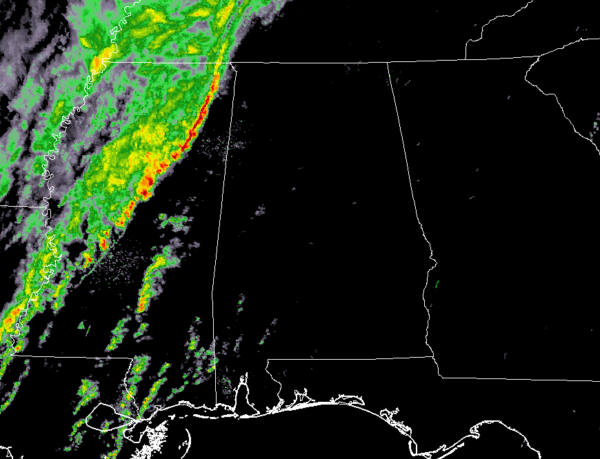
At 4:08 pm: The line of heavy rain and a few thunderstorms is now approaching the MS/AL state line and will be entering the western portions of Lauderdale, Colbert, and Franklin counties shortly. None of the activity is currently severe but there was a brief tornado warning for a cell moving through southern Mississippi that only lasts for around 11 minutes.
No active severe weather watches have been issued so far and we may stay watch free through the event, but then again, we have seen a slight uptick in values across the area during the day.
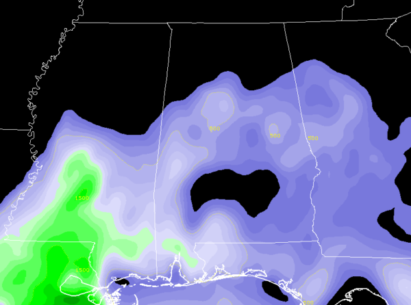
We are currently seeing instability creeping up across the southern 2/3rds of the area as CAPE values are approaching 500 J/kg and reaching as high as 800 J/kg in the southwestern parts of the area. Shear in the same locations are in the 50-65 knot range which would support severe storms. There is a good bit of helicity over the northern half of the area, but with it displaced from the instability and shear, severe storm development is unlikely.
Significant Tornado Parameter values are less than 1.0 over the area at this point, but as the line moves closer and into the area, those values will begin to approach 2.0.
At this point, isolated damaging wind gusts up to 60 MPH are possible along with a non-zero threat of a brief tornado.
As I was typing this post, NWS Huntsville issued a Significant Weather Advisory for parts of Lauderdale, Colbert, and Franklin counties. Radar was tracking strong thunderstorms along a line extending from near Pickwick Landing State Park to near Mantachie, Mississippi. The movement was east at 40 mph.
We’ll keep you updated through the event. Stay tuned.
Category: Alabama's Weather, ALL POSTS, Severe Weather
About the Author (Author Profile)
Scott Martin is an operational meteorologist, professional graphic artist, musician, husband, and father. Not only is Scott a member of the National Weather Association, but he is also the Central Alabama Chapter of the NWA president. Scott is also the co-founder of Racecast Weather, which provides forecasts for many racing series across the USA. He also supplies forecasts for the BassMaster Elite Series events including the BassMaster Classic.Subscribe
If you enjoyed this article, subscribe to receive more just like it.


