EXPIRED – Flood Warning For Parts Of Blount, Etowah, St. Clair, Cherokee Counties Until 7:30 PM
The National Weather Service in Birmingham has issued a
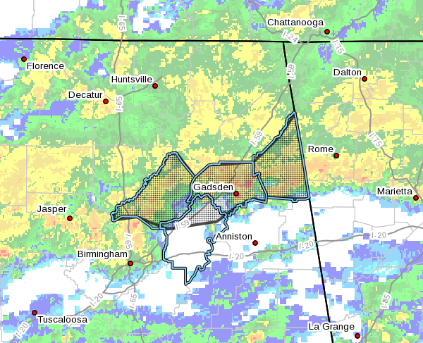
* Flood Warning for…
Blount County in central Alabama…
Etowah County in northeastern Alabama…
Northern St. Clair County in central Alabama…
Cherokee County in northeastern Alabama…
* Until 730 PM CST Tuesday.
* At 129 PM CST, Doppler radar indicated thunderstorms producing
heavy rain which will cause flooding. Between one and two inches
of rain has already fallen.
* Some locations that will experience flooding include…
Gadsden, Rainbow City, Oneonta, Attalla, Hokes Bluff, Springville,
Centre, Cedar Bluff, Blountsville, Cleveland, Little River Canyon
National Preserve, Forney, Centre Municipal Airport, Dallas,
Glencoe, Warrior, Ashville, Sardis City, Locust Fork and Steele.
PRECAUTIONARY/PREPAREDNESS ACTIONS…
Turn around, don’t drown when encountering flooded roads. Most flood
deaths occur in vehicles.
Please report flooding to your local law enforcement agency when you
can do so safely.
A Flood Warning means that flooding is imminent or occurring. All
interested parties should take necessary precautions immediately.
Category: Alabama's Weather, ALL POSTS, Severe Weather
About the Author (Author Profile)
Scott Martin is an operational meteorologist, professional graphic artist, musician, husband, and father. Not only is Scott a member of the National Weather Association, but he is also the Central Alabama Chapter of the NWA president. Scott is also the co-founder of Racecast Weather, which provides forecasts for many racing series across the USA. He also supplies forecasts for the BassMaster Elite Series events including the BassMaster Classic.Subscribe
If you enjoyed this article, subscribe to receive more just like it.


