A Damp, Cool, & Dreary Midday Across Much Of Central Alabama
RAIN AT TIMES THROUGH THE REST OF YOUR MONDAY
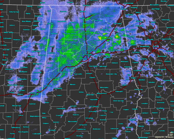
The main rain band that is over the north and northwestern parts of the area will continue to move across the area throughout the remainder of the daylight hours. After the main band, we could see a lull in the activity with a few lingering showers possible before a secondary line of showers moves through during the late-night and overnight hours. Some thunder is possible but not likely. Highs will range from the mid-50s to the mid-60s across the area.
Temperatures as of the noon Roundup were in the mid-40s to the upper 50s across the area. Birmingham was at 49 degrees. The warm spot was Troy at 59 degrees while the cold spot was Haleyville at 45 degrees.
SHOWERS EXIT ON TUESDAY; MAY RETURN ON WEDNESDAY FOR SOME
That second band of showers may take its time moving out of the eastern and southeastern parts of the area during the morning hours on Tuesday, but we should mainly dry out all across the area for the late morning through the remainder of the day. Highs will range from near 60 degrees in the northwest to the lower 70s in the southeast. Shower chances will start to increase during the overnight hours.
Another impulse will be sweeping across the area that may drag a few showers across the northern two-thirds of Central Alabama through the daylight hours on Wednesday. The overall chance of rain for anyone north of the I-85 corridor is small, while south of that will remain dry. Highs will range from the upper 40s to the lower 60s from northwest to southeast.
NWS BIRMINGHAM SKYWARN STORM SPOTTER TRAINING
The National Weather Service office in Birmingham will be offering several online Basic Spotter Courses and a single Advanced Spotter Course over the next few months. These online courses are FREE and are open to anyone who would like to learn more about what it takes to be a spotter and what to look for. More information can be found on the NWS Birmingham’s website, just CLICK HERE to visit the site.
BEACH FORECAST
Get the latest weather and rip current forecasts for the beaches from Bay St. Louis, MS, to Panama City Beach, FL, on our Beach Forecast Center page. There, you can select the forecast of the region that you are interested in.
ADVERTISE WITH THE BLOG!
We had another fantastic year in 2019 with just over 17 million page views! That brings our total for the last 2 years close to 37 million page views! Don’t miss out! We can customize a creative, flexible, and affordable package that will suit your organization’s needs. Contact Bill Murray at (205) 687-0782.
E-FORECAST
Get the Alabama Wx Weather Blog’s Seven-Day Forecast delivered directly to your inbox by email twice daily. It is the most detailed weather forecast available in Central Alabama. Subscribe here… It’s free!
CONNECT WITH THE BLOG ON SOCIAL MEDIA
You can find the AlabamaWx Weather Blog on the major social media networks:
Facebook
Twitter
Instagram
WEATHERBRAINS
Don’t forget you can listen to our weekly 90 minute netcast anytime on the web at WeatherBrains.com or on Apple Podcasts, Stitcher, or Spotify. This is the show all about weather featuring many familiar voices, including the meteorologists at ABC 33/40.
Category: Alabama's Weather, ALL POSTS
About the Author (Author Profile)
Scott Martin is an operational meteorologist, professional graphic artist, musician, husband, and father. Not only is Scott a member of the National Weather Association, but he is also the Central Alabama Chapter of the NWA president. Scott is also the co-founder of Racecast Weather, which provides forecasts for many racing series across the USA. He also supplies forecasts for the BassMaster Elite Series events including the BassMaster Classic.Subscribe
If you enjoyed this article, subscribe to receive more just like it.


