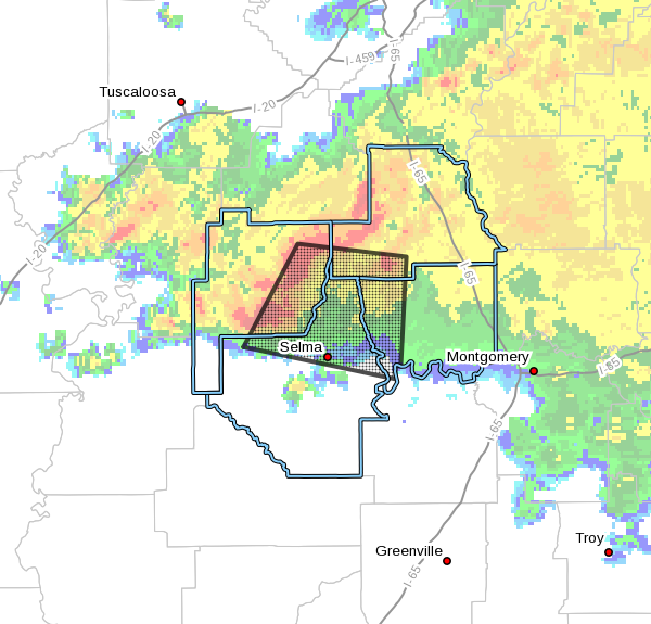
EXPIRED – Severe Thunderstorm Warning For Autauga, Chilton, Dallas, Perry Counties Until 7:45 AM
The National Weather Service in Birmingham has issued a
* Severe Thunderstorm Warning for…
Western Autauga County in central Alabama…
Southwestern Chilton County in central Alabama…
Northeastern Perry County in central Alabama…
Northern Dallas County in south central Alabama…
* Until 745 AM CST.
* At 643 AM CST, severe thunderstorms were located along a line
extending from 9 miles east of Heiberger to near Marion Junction,
moving southeast at 40 mph.
HAZARD…60 mph wind gusts and quarter size hail.
SOURCE…Radar indicated.
IMPACT…Hail damage to vehicles is expected. Expect wind damage
to roofs, siding, and trees.
* Locations impacted include…
Selma, Valley Grande, Selmont-West Selmont, Plecher, Mulberry,
Gardner Island, Parnell, Paul M Grist State Park, Memorial Stadium,
Burnsville, Potter Station, Radford, Stanton, Summerfield, Valley
Creek Junction, Plantersville, Suttle, Edmund Pettus Bridge, Selma
University and Barrett Creek.
PRECAUTIONARY/PREPAREDNESS ACTIONS…
A Tornado Watch remains in effect until 1100 AM CST for central and
south central Alabama.
For your protection move to an interior room on the lowest floor of a
building.
Torrential rainfall is occurring with these storms, and may lead to
flash flooding. Do not drive your vehicle through flooded roadways.
Category: Alabama's Weather, ALL POSTS, Severe Weather
About the Author (Author Profile)
Scott Martin is an operational meteorologist, professional graphic artist, musician, husband, and father. Not only is Scott a member of the National Weather Association, but he is also the Central Alabama Chapter of the NWA president. Scott is also the co-founder of Racecast Weather, which provides forecasts for many racing series across the USA. He also supplies forecasts for the BassMaster Elite Series events including the BassMaster Classic.Subscribe
If you enjoyed this article, subscribe to receive more just like it.


