SPC Mesoscale Discussion: Overall Severe Threat Slowly Diminishing
The severe weather threat for Tornado Watch 38 continues.
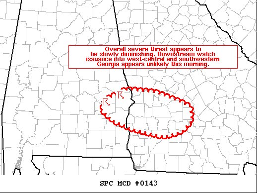
SUMMARY…Overall severe threat across east-central AL appears to be slowly diminishing. Downstream watch issuance into west-central/southwestern GA appears unlikely this morning.
DISCUSSION…A small, low-topped cluster of storms is ongoing across parts of east-central AL at 1515Z. Although strong flow aloft is present over this region, instability remains rather weak owing to persistent cloud cover and poor mid-level lapse rates. Better forcing for ascent should gradually shift northward and away from west-central/southwestern GA through the remainder of the morning and continuing into the afternoon. This should lead to a gradually diminishing trend to the ongoing convection. Regardless, an isolated strong wind gust cannot be ruled out across a small part of east-central AL in the short term (next hour or so). Given current observational trends, downstream watch issuance into west-central/southwestern GA will probably not be needed.
Category: Alabama's Weather, ALL POSTS, Severe Weather
About the Author (Author Profile)
Scott Martin is an operational meteorologist, professional graphic artist, musician, husband, and father. Not only is Scott a member of the National Weather Association, but he is also the Central Alabama Chapter of the NWA president. Scott is also the co-founder of Racecast Weather, which provides forecasts for many racing series across the USA. He also supplies forecasts for the BassMaster Elite Series events including the BassMaster Classic.Subscribe
If you enjoyed this article, subscribe to receive more just like it.


