At Midday: Nearly All Rain Staying South Of The I-20 Corridor
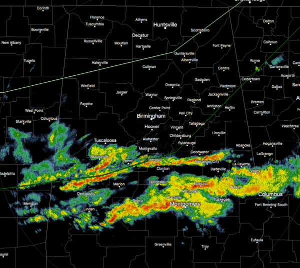
As of 12:10 pm, nearly all of the rain and thunderstorms are staying south of a line from Tuscaloosa to Montevallo to Roanoke. The good news is that none of these storms are acting up and are staying well below severe limits. The bad news is that the rainfall is moderate to heavy and is falling over the same general locations as they are moving eastward. North of that line, skies are starting to clear up just enough to let some sunshine down to the surface.
Temperatures were in the mid-60s to the mid-70s across the area at this time. Troy was leading the way at 75 degrees with cloudy skies. Auburn was the cool spot at 64 degrees with rain. Birmingham had partly sunny skies at 71 degrees.
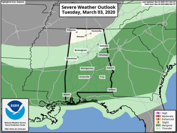
We still have a Marginal Risk for severe storms throughout the rest of the daylight hours for locations along and south of a line from Boligee to Brent to Talladega Springs to Oxford to just east of Piedmont. Isolated damaging wind gusts up to 60 MPH and quarter-sized hail are the main threats. While a brief tornado is not likely, there is still a non-zero chance of one occurring.
Much of the activity looks to stay over the southern half of Central Alabama during much of the rest of the daylight hours before the higher chances flip-flop and the northern half gets much of the activity for the late afternoon and through the rest of the evening and late-night hours. Afternoon highs will top out in the lower to mid-70s across the area. More moderate to heavy rainfall is projected to move over the central parts of Central Alabama during the overnight hours. While a rumble or two of thunder is possible, no severe storms are expected. Lows will drop into the lower 50s to the lower 60s across the area from north to south.
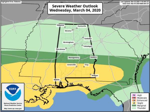
Rain and storms will be likely throughout the day on Wednesday and a few of those may be strong to severe over the southern parts of the area. SPC has a Slight Risk up for locations along and south of a line from Butler to Fort Deposit to Midway. A Marginal Risk is up for locations north of that to a line stretching from Geiger to Maplesville to Opelika. Once again, damaging winds up to 60 MPH, quarter-size hail, and a brief tornado will be possible. Highs will be much cooler only topping out in the upper 50s to the lower 60s across the area.
Nashville, Middle Tennessee gutted by deadly tornadoes; more than 20 now dead. See more photos here: https://t.co/0jPvni1Re0 @spann. pic.twitter.com/BcZUx4QQp6
— MontgomeryAdvertiser (@MGMAdvertiser) March 3, 2020
The news out of Nashville continues to worsen as the confirmed death toll is now up to 21. Early estimates from NWS Nashville have the Mount Juliet and Donelson tornadoes rated as EF3 with maximum wind speeds estimated at 155-165 MPH. Both location’s damage could be caused by the same tornado as this is based on those neighborhoods and surveys are not complete.
We may have had tornadoes earlier this morning in portions of Hale and Bibb counties. parts of Greensboro suffered some major damage as a few homes were completely destroyed and a few more with damage. No reports of injuries in Alabama as of the noon report. NWS Birmingham will have survey teams out tomorrow to take a look at the damage.
Category: Alabama's Weather, ALL POSTS, Severe Weather
About the Author (Author Profile)
Scott Martin is an operational meteorologist, professional graphic artist, musician, husband, and father. Not only is Scott a member of the National Weather Association, but he is also the Central Alabama Chapter of the NWA president. Scott is also the co-founder of Racecast Weather, which provides forecasts for many racing series across the USA. He also supplies forecasts for the BassMaster Elite Series events including the BassMaster Classic.Subscribe
If you enjoyed this article, subscribe to receive more just like it.


