Lots More Rain Ahead for Alabama
Daylight Saving Time began this morning at 2 a.m. local time. Did you remember to spring forward, setting any clocks that don’t automatically adjust to DST ahead one hour? If not, you’re late.
PROGRESSIVE PATTERN: The upper air pattern across the U.S. continues to be active and progressive, meaning that features are zipping along quickly. Yesterday’s ridge is being replaced by a minor trough today, but you will hardly notice it. You will notice the next system, though, which will affect us for the first half of the new work week.
SUNNY SUNDAY: But for today, very nice early March weather is in store. Most locations are in the middle and upper 30s this morning, with a few of the normally colder locations over Northeast Alabama near freezing. Temperatures will warm nicely under partly cloudy skies into the lower and middle 60s generally. A breezy southerly wind will feel nice. Tonight’s lows will be limited to the lower and middle 40s, as skies become cloudy toward morning ahead of that next weathermaker.
WET START TO THE WORK WEEK: Rain should enter Alabama from the west Monday morning as increasing energy from a disturbance moving into the Midwest triggers fairly widespread showers. Batches of rain will follow through the afternoon Monday, into Monday night, probably lasting until Tuesday morning and perhaps even Tuesday afternoon. There could be a few rumbles of thunder Monday afternoon, but no strong or severe thunderstorms are expected. Highs on Monday and Tuesday will be near 70F, with lows Monday night in the middle and upper 50s.
THE RAIN DOESN’T STOP THERE: The high pressure to the east of Alabama will be very stubborn, as they tend to increasingly be as we head toward spring. A second system will approach the area Wednesday afternoon or night and this slow-moving front will keep showers in the forecast for Central Alabama until Friday morning. Despite the rain, expect lower 70s for highs Wednesday, Thursday, and Friday. Overnight lows will be in the 50s.
BRIEF RESPITE, THEN MORE RAIN: There will be a short break, likely Friday afternoon and evening, but another approaching front will trigger more rain on Saturday and Sunday. Highs will still hover around 70F.
VOODOOLAND: More rain looks likely between the 17th and 21st. That sounds like a lot of rain, doesn’t it?
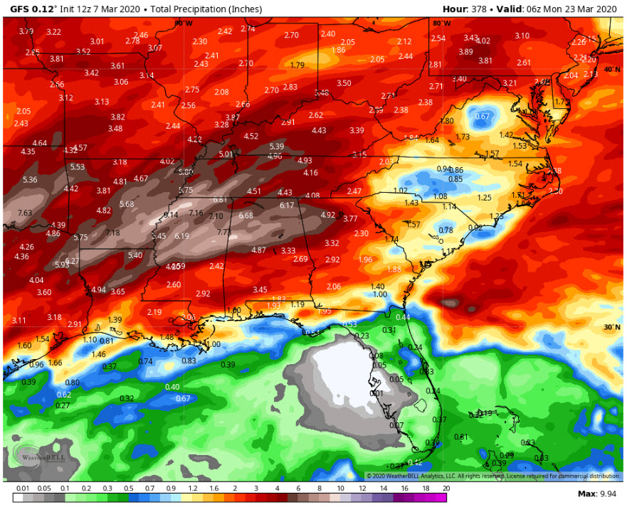
16 day rainfall totals off the GFS
RAINFALL TOTALS: 16-day totals off the GFS are running 6-10 inches in the I-59 Corridor. That could be a mess.
BEACHCAST: Showers are in the offing along the beautiful beaches of Alabama and Northwest Florida in the week ahead. No lengthy periods of rain or any washouts, but showers are possible Tuesday, Wednesday, and Friday. Highs will be well into the 70s. Lows will be in the 60F range. Water temperatures along the Gulf are running around 63F.
Click here to see the Beach Forecast Center page.
NATIONALLY: Things are actually fairly serene across the country this morning. The coastal plains of Georgia and the Carolinas are under freeze warnings this morning. Dozens of flood warnings blanket the southern United States, as well as the rivers in Iowa and Minnesota. The wind is sweeping downs the plains in Oklahoma, as well as in Kansas, where wind advisories are in effect. Winter weather advisories are in effect for the northern Sierra mountains of California.
DANCING WITH THE STATS: An impressive 17.73 inches of rain fell at Birmingham during the 30 day period from February 5-March 5. This ranks as the 43rd wettest 30 day period in Magic City history. But all of those top 50 events came out of just five years: 1916, 1961, 1983, 2003, and now 2020. Looking at it this way, our recent event ranks as the fifth wettest in Birmingham history overall.
ADVERTISE WITH US: Deliver your message to a highly engaged audience by advertising on the AlabamaWX.com website. The site enjoyed 17.2 MILLION pageviews in the past 12 months. Don’t miss out! We can customize a creative, flexible and affordable package that will suit your organization’s needs. Contact me, Bill Murray, at (205) 687-0782 and let’s talk.
WEATHERBRAINS: This week, the panel will entertain Curtis Alexander from the Nationial Mesonet. Check out the show at www.WeatherBrains.com. You can also subscribe on iTunes. You can watch the show live at live.bigbrainsmedia.com or on James’ YouTube Channel You will be able to see the show on the James Spann 24×7 weather channel on cable or directly over the air on the dot 2 feed.
ON THIS DATE IN 1932: A powerful extratropical low pressure system set numerous record low pressures from Virginia to New England. The storm deepened southeast of New Orleans, then headed northeast, passing over eastern North Carolina and then offshore east of Atlantic City to then over Newport RI. Block Island RI recorded a barometric reading of 28.20 inches, the lowest pressure observed in the contiguous United States outside of a tropical hurricane. At Norfolk, the pressure fell to 28.35”; Raleigh NC 28.57”; Charleston SC 28.78”; Washington DC to 28.67”; Atlantic City NJ to 28.20” and Boston to 28.45”, all records. Surprisingly, the storm was not accompanied by as much wind as would be expected from low pressure of this extreme magnitude. The powerful low pressure system passed through Texas and into the Gulf of Mexico, where it recurved northeastward, to a point southeast of New Orleans, near Raleigh and then to the east of Atlantic City and over Newport, Rhode Island. Follow my weather history tweets on Twitter. I am @wxhistorian at Twitter.com.
Category: Alabama's Weather, ALL POSTS
About the Author (Author Profile)
Bill Murray is the President of The Weather Factory. He is the site's official weather historian and a weekend forecaster. He also anchors the site's severe weather coverage. Bill Murray is the proud holder of National Weather Association Digital Seal #0001 @wxhistorianSubscribe
If you enjoyed this article, subscribe to receive more just like it.


