Marginal Severe Storm Threat Continues For Just a Little Bit Longer
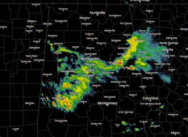
As of 5:15 pm, all of the Severe Thunderstorm Warnings have been cancelled along with many of the counties that were in the Severe Thunderstorm Watch. Rain and thunderstorms stretch from Fruithurst and Heflin to Waldo and Childersburg to Marion and Uniontown and Linden.
The stronger storms are capable of producing some small hail, especially over Wedowee, just east of Talladega and Munford, and stretching from Demopolis to Thomaston and Orrville.
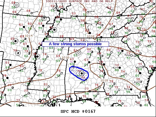
The latest Mesoscale Discussion from the Storm Prediction Center states that a few strong storms will spread southeast this evening. Marginally severe hail and gusty winds are the primary threats.
Remnants of long-lived MCS have progressed across the Mid-South region into central Alabama this evening. This cluster of storms has been supported by a notable short-wave trough that is digging southeast across TN/northern AL. Buoyancy is somewhat limited downstream ahead of the short wave so this complex has gradually weakened over the last few hours. Even so, a few strong-marginally severe thunderstorms remain possible, especially along the southwestern flank of the MCS. The greatest risk for hail/wind should be along a corridor from Hale-Dallas-Lowndes Counties.
We’ll keep you posted.
Category: Alabama's Weather, ALL POSTS, Severe Weather
About the Author (Author Profile)
Scott Martin is an operational meteorologist, professional graphic artist, musician, husband, and father. Not only is Scott a member of the National Weather Association, but he is also the Central Alabama Chapter of the NWA president. Scott is also the co-founder of Racecast Weather, which provides forecasts for many racing series across the USA. He also supplies forecasts for the BassMaster Elite Series events including the BassMaster Classic.Subscribe
If you enjoyed this article, subscribe to receive more just like it.


