All Quiet Here At Midday; Tornado Threat Increasing Off To Our North & Northwest
As we have reached the midday hour across North/Central Alabama, everything remains quiet at this point. No shower or thunderstorm activity is currently active across the area. As a matter of fact, much of Central Alabama is enjoying plenty of sunshine, where much of North Alabama and the extreme northern parts of Central Alabama have clouds to deal with.
Temperatures as of the 12:00 pm Round-Up were in the upper 60s to the upper 70s across Central Alabama. Haleyville was the cool spot at 68 degrees while Montgomery was leading the way at 77 degrees. Birmingham was at 73 degrees.
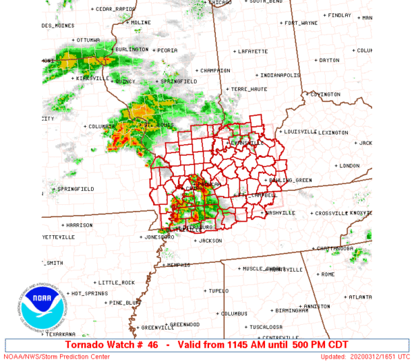
The active weather is off to our north and northwest in western portions of Kentucky, northwestern portions of Tennessee, the extreme southern parts of Illinois and Indiana, and the extreme southeastern tip of Missouri. A few thunderstorm complexes are rolling through those regions that are capable of producing damaging winds in excess of 60 MPH and large hail. A tornado threat will begin to take shape shortly and therefore a Tornado Watch has been issued until 5:00 pm for those locations.
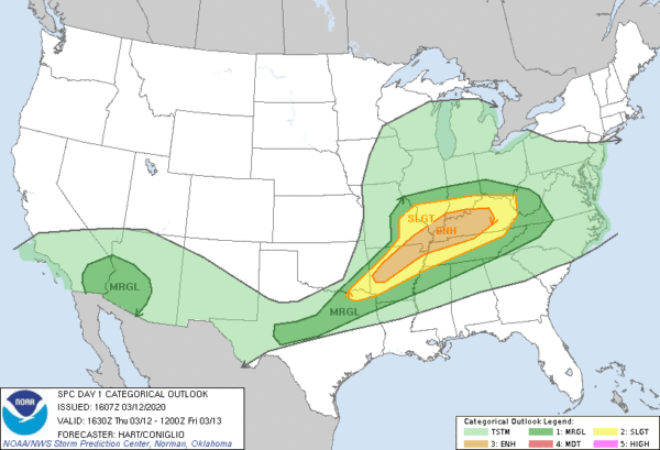
As you can see, an Enhanced Risk for severe storms is up from Central Arkansas through Southeastern Missouri, Southern Illinois, Southern Indiana, much of Kentucky, and Northwest Tennessee. A Slight Risk is up stretching out from and surrounding the Enhanced Risk locations.
You will also notice that a Marginal Risk stretches down into North Alabama. There will be a weakening cluster of storms pushing down and entering into the area from the northwest around 8:00 pm to 10:00 pm that could produce strong winds and some hail, but much of the activity should stay just below severe criteria. The line will continue weakening as it moves southeast.
So for today, much of Central Alabama will stay dry throughout the daylight hours, but there will be a very small chance of a few scattered showers and maybe a thunderstorm over the northern third of the area before sunset. Afternoon highs will be in the mid-70s to the lower 80s across the area from north to south. Rain chances will increase as that cluster of storms along with a cold front will move into the northern parts of the area before midnight and sweep through much of the area during the overnight hours. While a strong storm is possible in the extreme northern parts of the area, severe weather is not likely at this point. Rain chances will be the highest north of the I-20 corridor and will be steadily dropping as you move southeast. Lows will be in the upper 50s to the mid-60s.
The cold front will continue to work through the area on Friday, making rain and a few thunderstorms likely across nearly the entire area. High temperatures will range from the lower 60s to the upper 70s from northwest to southeast with many of the highs in the northern half of the area occurring during the early morning hours. No threat of strong to severe weather for Central Alabama on Friday.
Category: Alabama's Weather, ALL POSTS, Severe Weather
About the Author (Author Profile)
Scott Martin is an operational meteorologist, professional graphic artist, musician, husband, and father. Not only is Scott a member of the National Weather Association, but he is also the Central Alabama Chapter of the NWA president. Scott is also the co-founder of Racecast Weather, which provides forecasts for many racing series across the USA. He also supplies forecasts for the BassMaster Elite Series events including the BassMaster Classic.Subscribe
If you enjoyed this article, subscribe to receive more just like it.


