At Midday, Showers For The Northwest Corner; A Few Strong Storms Remain Possible Later Today
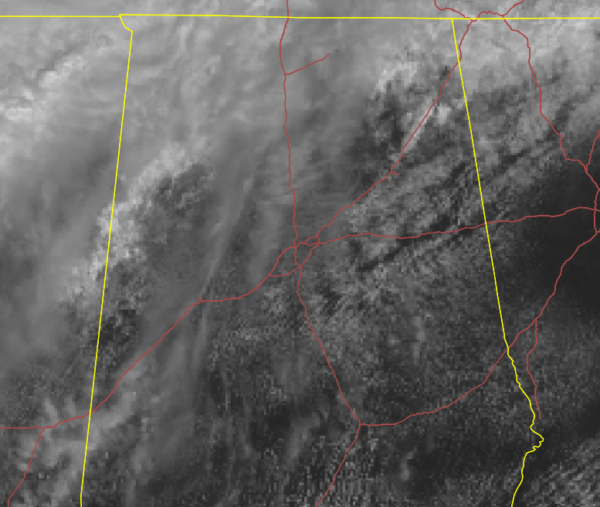
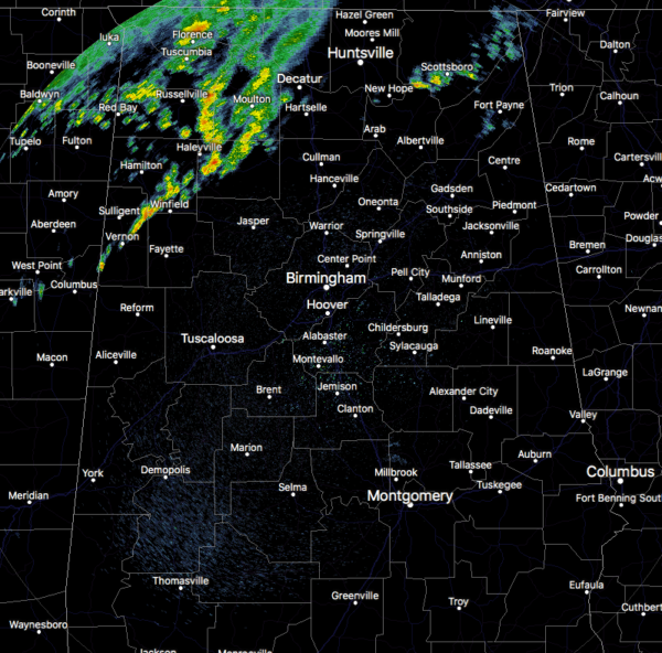
At 11:45 am, while much of Central Alabama is seeing a decent bit of sunshine, the northwest corner of the area and up into North Alabama is covered with clouds. Underneath the clouds in the northwestern parts of Central Alabama and the western half of North Alabama, we have showers falling. Nothing too heavy or strong at the moment, but we’ll have to keep our eyes open for later this afternoon and into the evening.
The good news is that we do not have the wind fields in place for tornadoes today, but we do have a set up to where we could have some hail up to 1-inch in diameter and isolated damaging wind gusts up to 60 MPH.
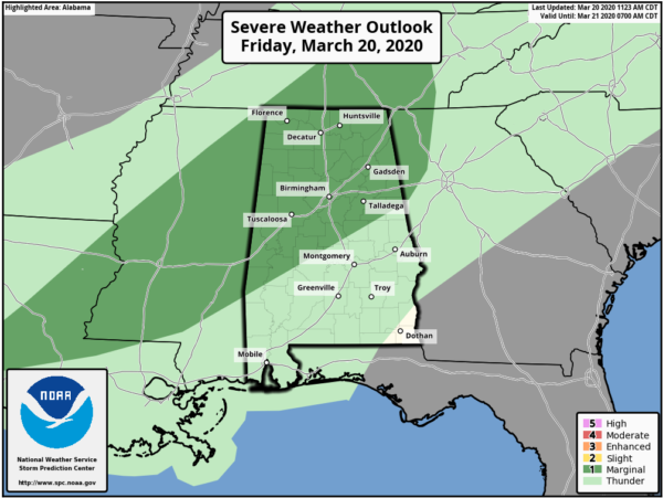
The latest updated graphic from the SPC continues to have all of North Alabama and much of Central Alabama in a Marginal Risk for severe storms throughout today.
Temperatures as of this time were in the mid-60s to the upper 70s across the area. The cool spot was Haleyville at 66 degrees while the warm spot was Troy at 79 degrees. Birmingham was at 75 degrees, Tuscaloosa was at 78 degrees, and 72 degrees at Huntsville.
Rain and thunderstorms will begin to move more into the area during the afternoon hours as a cold front will continue to push toward Central Alabama. Rain and storms will be likely north of a line from Demopolis to Clanton to Wedowee through sunset, but those will continue to slide east and south and will encompass much of the rest of the area by midnight before chances really start to decrease. Highs should top out in the mid-70s to the mid-80s across the area. Strong storms will be possible from noon through 7:00 pm for those locations in the Marginal Risk. Lows tonight will be in the upper 40s to the mid-60s.
The cold front will be located over the southeastern corner of the state that may keep a few small shower chances in the forecast for locations along and south of the I-85 corridor, and maybe a stray shower or two as far north as the I-20 corridor. Skies will continue to be mostly cloudy and highs will be cooler, only reaching the 60s for the northern half of the area and the 70s for the southern half.
Category: Alabama's Weather, ALL POSTS, Severe Weather
About the Author (Author Profile)
Scott Martin is an operational meteorologist, professional graphic artist, musician, husband, and father. Not only is Scott a member of the National Weather Association, but he is also the Central Alabama Chapter of the NWA president. Scott is also the co-founder of Racecast Weather, which provides forecasts for many racing series across the USA. He also supplies forecasts for the BassMaster Elite Series events including the BassMaster Classic.Subscribe
If you enjoyed this article, subscribe to receive more just like it.


