CANCELED – Flash Flood Warning For Parts Of Jackson & Madison Counties Until 2:00 PM
The National Weather Service in Huntsville Alabama has issued a
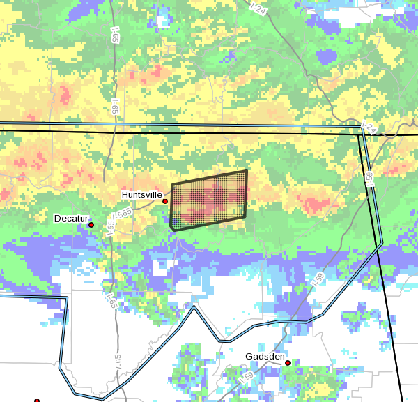
* Flash Flood Warning for…
West central Jackson County in northeastern Alabama…
Central Madison County in north central Alabama…
* Until 200 PM CDT.
* At 804 AM CDT, Doppler radar and automated gauges indicated
thunderstorms producing heavy rain across the warned area. Up to
one and a quarter inches of rain has already fallen around
Huntsville in the past hour,and these storms are moving east-
northeast. Flash flooding is ongoing or expected to begin shortly.
HAZARD…Flash flooding caused by thunderstorms.
SOURCE…Radar and automated gauges.
IMPACT…Flooding of small creeks and streams, urban areas,
highways, streets and underpasses as well as other
drainage and low lying areas.
* Some locations that will experience flooding include…
Huntsville, Owens Cross Roads, Gurley, Woodville, Pleasant Groves,
Paint Rock, Maysville, Hampton Cove, Brownsboro and Farley.
PRECAUTIONARY/PREPAREDNESS ACTIONS…
Turn around, don’t drown when encountering flooded roads. Most flood
deaths occur in vehicles.
A Flash Flood Warning means that flooding is imminent or occurring.
If you are in the warned area move to higher ground immediately.
Residents living along streams and creeks should take immediate
precautions to protect life and property.
Category: Alabama's Weather, ALL POSTS, Severe Weather
About the Author (Author Profile)
Scott Martin is an operational meteorologist, professional graphic artist, musician, husband, and father. Not only is Scott a member of the National Weather Association, but he is also the Central Alabama Chapter of the NWA president. Scott is also the co-founder of Racecast Weather, which provides forecasts for many racing series across the USA. He also supplies forecasts for the BassMaster Elite Series events including the BassMaster Classic.Subscribe
If you enjoyed this article, subscribe to receive more just like it.


