

Severe Weather Threat Continues This Evening
A severe weather threat continues for North and Central Alabama this evening. The threat of severe weather continues for the area north of a line from Demopolis to Clanton to Allex City.
Here is the big picture at 7:45:
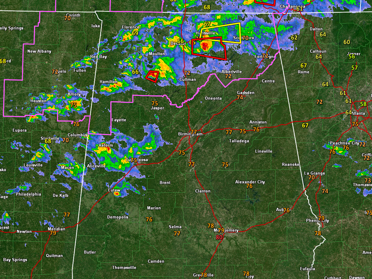
There is one tornado warning left, for Madison and Marshall Counties. This storm is approaching New Hope, Woodville, and Grant. This storm will pass north of Morgan City. It has a good bit of lightning.
Heavy showers in the Tuscaloosa area are intensifying and could produce lightning soon. They will move across Tuscaloosa, northern Bibb, southern Jefferson, and Shelby Counties.
Low to moderate instability continues over North Alabama tonight with 500-1,000 joules/kg of CAPE.

There is decent bulk wind shear and decent low-level helicity. The result is low topped supercells that are pushing east southeast ahead of a low-pressure system that will move across the Tennessee Valley tonight along with a cold front that will push into Central Alabama by tomorrow evening.

A tornado watch continues for the northern third of the state. The tornado watch is being extended in area to include Blount, Chrokee and Etowah Counties. This watch extends into Georgia. It will go until midnight.

The area south ofo the current tornado watch does not appear to have enough of a threat to warrant an extension of the tornado watch into the Tuscaloosa, Birmingham, and Anniston areas.
Instabilities swill diminish during the evening and the severe threat will slowly subside.
There was a significant tornado late this afternoon at Tishomingo, MS. This storm did cross into Franklin and eventually Lawrence Counties. No damage in Alabama. This storm is in Marshall County now.
EMA reports no damage in Hacklleburg or Bear Creek in Marion County from the second tornado warned storm earlier.
Instabilities swill diminish during the evening and the severe threat will slowly subside.
Category: Alabama's Weather, ALL POSTS, Severe Weather
About the Author (Author Profile)
Bill Murray is the President of The Weather Factory. He is the site's official weather historian and a weekend forecaster. He also anchors the site's severe weather coverage. Bill Murray is the proud holder of National Weather Association Digital Seal #0001 @wxhistorianSubscribe
If you enjoyed this article, subscribe to receive more just like it.


