Late Afternoon Check On Our Potential For Strong/Severe Storms Later Tonight
As of 4:15 pm, we are quiet across North/Central Alabama as we are getting to enjoy some nice but very warm weather. Temperatures were in the 80s at this point with Troy leading the way at 88 degrees. Birmingham was at 84 degrees. Cullman was the cool spot at 80 degrees.
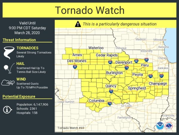
While it is quiet down here in the “Deep South,” our friends to the north of us as parts of Iowa, Missouri, and Illinois are under a rare PDS Tornado Watch until 9:00 pm tonight. Tornadoes, some of which look may be strong, damaging winds up to 70 MPH, and large hail up to tennis ball-size are the main threats for those locations in the watch. We won’t see any of that down this way late tonight through the overnight hours, but we could have a couple strong to severe storms around and after midnight.
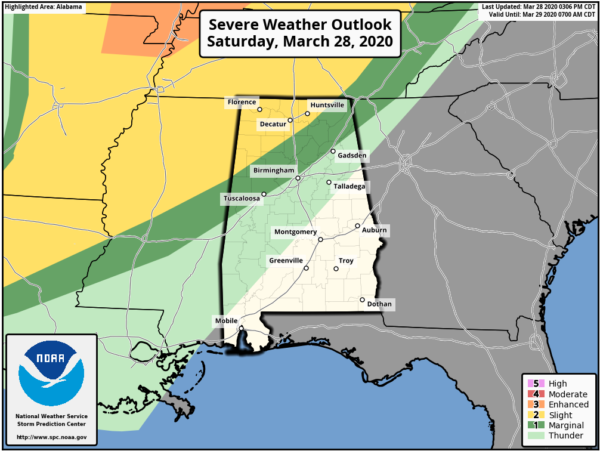
The latest update from the Storm Prediction Center and it shows that both the Slight Risk and Marginal Risk have been extended to the south and east slightly. The Slight Risk now includes locations along and north of a line from just north of Millport (Lamar Co.) to just north of West Point (Cullman Co.) to just south of Hytop (Jackson Co.). The Marginal Risk now extends south of the slight risk to a line stretching from Gainesville (Sumter Co.) to Tarrant (Jefferson Co.) to Sand Rock (Cherokee Co.).
A weakening line of storms will be moving into the northwestern part of the state ahead of a cold front that will have the potential for a few stronger to severe storms with damaging winds up to 60 MPH and large hail up to one-inch in diameter being the main threats. A brief tornado or two are possible, but they will not be likely.
Timing for the threat of severe storms in the risk locations will start tonight around 11:00 pm to 12:00 am in the extreme northwest and will progress across the area until the threat is expected to subside around 4:00 am Sunday. The line of rain and storms will continue to push eastward across the rest of the area, but the atmosphere should be more stable and severe weather will not be expected after 4:00 am.
We’ll have sufficient instability built up after the daytime heating, but that will be declining after the sun sets. While much of the forcing and dynamics will be well to our north, it may be just close enough that we’ll have to keep our eyes on the line as it moves into the area.
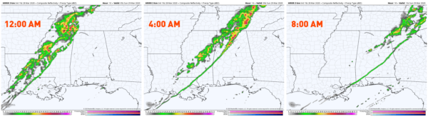
The latest run of the HRRR has the line of rain and storms pushing into the northwestern parts of North/Central Alabama around midnight and will be progressing eastward while weakening throughout the overnight hours. The line looks to be arriving in the Birmingham metropolitan area sometime around 4:00 am-5:00 am and will begin moving out of the state by 8:00 am.
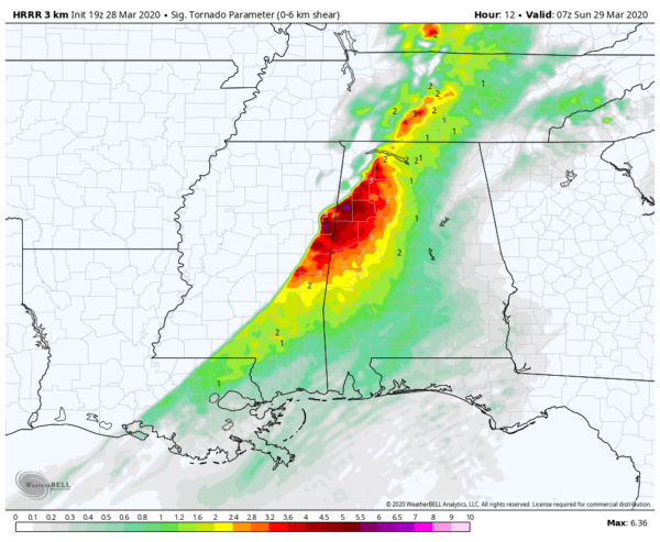
The latest HRRR also shows the Significant Tornado Parameter values approaching 6.0 in portions of Lamar County and 5.0 for portions of Lamar, Fayette, and Pickens counties around 1:00 am. While we are not expecting an outbreak of tornadoes tonight, these locations are where we would need to watch for a brief tornado or two.
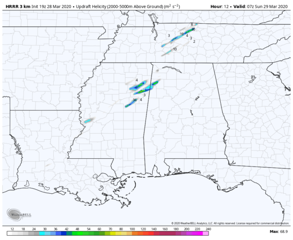
The latest Updraft Helicity markers from the same model run also valid at 1:00 am lines up with those STP values, showing the potential for rotating updrafts over portions of Lamar and Marion counties.
Bottom Line: We are in the middle of our Spring Severe Weather Season in North/Central Alabama. This is not expected to be a big event for us, but if you are in the risk locations, go ahead and have everything ready just in case you go under a warning. Have multiple ways to receive warnings, especially ones that will wake you during the overnight hours. We’ll keep you posted throughout the rest of the day and through the event tonight.
Category: Alabama's Weather, ALL POSTS, Severe Weather
About the Author (Author Profile)
Scott Martin is an operational meteorologist, professional graphic artist, musician, husband, and father. Not only is Scott a member of the National Weather Association, but he is also the Central Alabama Chapter of the NWA president. Scott is also the co-founder of Racecast Weather, which provides forecasts for many racing series across the USA. He also supplies forecasts for the BassMaster Elite Series events including the BassMaster Classic.Subscribe
If you enjoyed this article, subscribe to receive more just like it.


