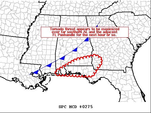
Tornado Threat Maximized Over Southern Alabama For The Next Hour Or So
SUMMARY…
Tornado risk appears to be maximized across southern portions of the WW area.
DISCUSSION…
The latest radar loop shows a discontinuous band of thunderstorms extending from near the Alabama/Georgia state line southwest of Atlanta, southwestward to extreme southeastern Mississippi, just ahead of a similarly oriented cold front advancing across the area.
The strongest portion of the band extends from roughly Troy County AL to near Mobile, with several cells exhibiting low-level rotation — both within the broken band of storms, as well as with cells that continue to increase ahead of the line over the Panhandle and into far southeast Alabama. The two storms which appear to have the strongest/deepest rotational radar signatures are one crossing central Escambia County at this time which is embedded within the main band, and a second/lone cell crossing Geneva County Alabama.
Storms over the southern portion of the watch — where the greatest (500 to 1000 J/kg) mixed-layer CAPE and low-level moisture (the upper 60s to near 70 dewpoints) exist — have shown a tendency to acquire rotation fairly rapidly upon corresponding increases in radar reflectivity. As such, and with 0-1km shear supportive of this tendency for low-level rotation, tornado probability will be increased to 10%/enhanced risk in the upcoming 10:30 am Day 1 outlook update.
Category: ALL POSTS
About the Author (Author Profile)
Scott Martin is an operational meteorologist, professional graphic artist, musician, husband, and father. Not only is Scott a member of the National Weather Association, but he is also the Central Alabama Chapter of the NWA president. Scott is also the co-founder of Racecast Weather, which provides forecasts for many racing series across the USA. He also supplies forecasts for the BassMaster Elite Series events including the BassMaster Classic.Subscribe
If you enjoyed this article, subscribe to receive more just like it.


