Potential Of Multiple Rounds Of Severe Storms For Next Few Days
The weather throughout the next several days will be busy across Central Alabama as we’ll have a few rounds of stronger to severe storms to deal with… now looking even more likely on Easter Sunday. We’ll start off with today…
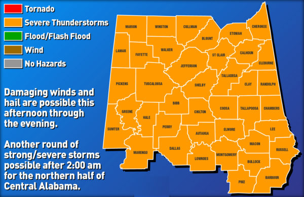
Hazardous Weather Outlook valid today 1:00 pm through 9:00 pm.
Strong to severe thunderstorms are possible across all of Central Alabama from 1:00 pm to 9:00 pm today. The primary threats include damaging winds up to 60 mph and quarter size hail.
As a cold front will be approaching the area and will move in during the overnight and into the pre-dawn hours on Thursday morning, Central Alabama will be in a very unstable zone called the “warm sector” where plenty of warm moist air from the Gulf of Mexico is being advected (pulled) into the area. There may be just enough forcing this afternoon that if any thunderstorms develop, they will have plenty of instability to feed off of.
Surface instability will be very high (2,000-3,000 J/kg), almost similar to what we would see during the summertime in Central Alabama. Combine that with 50-60 knots of bulk wind shear from the surface to 6 km, damaging winds up to 60 MPH will be possible. Also, lapse rates will be sufficient enough to support the potential of hail up to quarter size. The tornado threat, while not zero, is very very low due to the fact that we will be lacking the low-level directional shear needed for tornado development.
Not everyone will see a thunderstorm this afternoon and evening as these will be scattered in nature, but if one develops and moves over your location, there is the potential for it to become severe with the unstable atmosphere in place of Central Alabama. Stay aware and be prepared.
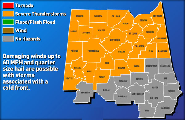
Hazardous Weather Outlook valid Thursday 2:00 am through 9:00 am.
There will be a break in the action during the late night and into the beginning of the overnight hours before a cold front moves into the area from the north-northwest and will move south-southeast through the area during pre-dawn and morning hours on Thursday, before moving out of Central Alabama around midday. Strong to severe thunderstorms are possible north of the I-20 corridor roughly from 2:00 am to 9:00 am Thursday morning. The primary threats include damaging winds up to 60 MPH and quarter size hail.
The atmosphere out ahead of the cold front will continue to be unstable as we’ll continue to have plenty of instability, bulk shear, and steeper lapse rates. Any thunderstorms that are active along and just ahead of the cold front will have the potential to be strong to severe. Once again, low-level directional shear will be rather low, so the threat of a tornado is very low, but not zero.
It’s not a guarantee that everyone will see storms with the cold front as the lack of daytime heating and the potential of a capping inversion forming due to the fact that we could see warm and drier air push into the area from the west-southwest. We’ll just have to wait and see as the front begins to move into the area.
Once the cold front passes your location, skies look to clear out rather quickly behind the cold front. High temperatures look to reach the lower 70s to the mid-80s across the area, but highs on Friday will only reach the lower 60s to the lower 70s.
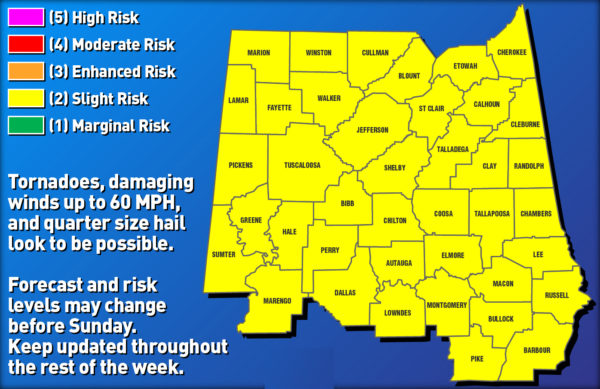
Severe Weather Outlook valid Sunday 7:00 am through Monday 7:00 am.
NWS Birmingham and the Storm Prediction Center has already placed Central Alabama in a Slight Risk for severe storms throughout the day on Easter Sunday and into the pre-dawn hours on Monday. At this point, all modes of severe weather look to be possible across the area.
There are still little inconsistencies between the European and GFS models in the timing and location of thunderstorm development. The European model continues to show a strong surface low pushing northeastward through the Mid-Mississippi Valley along with strong low-level and upper-level jets in place. Shear looks to be in the 70+ knots range, and with plenty of forcing with the low and approaching cold front, scattered to numerous thunderstorms look to form out ahead of the front with the main squall line pushing through later in the evening and overnight hours with the front.
The GFS is a little quicker with its solution which will bring the system through earlier and during a little more stable part of the day on Sunday. It also continues to try to develop storms across the Gulf Coast which would limit instability across the area.
The European has usually been more consistent in the past with severe systems for the southeast, so I will tend to side with it more than the GFS. The timing and specifics will be ironed out over the next couple of days especially when the higher-resolution and convection-allowing models come into focus.
Bottom line… This is our main severe weather season in Central Alabama and we have to watch every system carefully that moves through the area during this time. While I know it is Easter Sunday, please go ahead and have your safety kits and supplies ready along with your place of safety ready to go well in advance. Be sure to have fresh batteries in your NOAA WeatherRadio and have a fresh set in your flashlights. While this does not appear to be a major outbreak, all it takes is for one tornado to come down your street to make it a major ordeal. Be prepared… Be weather aware.
Category: Alabama's Weather, ALL POSTS, Severe Weather
About the Author (Author Profile)
Scott Martin is an operational meteorologist, professional graphic artist, musician, husband, and father. Not only is Scott a member of the National Weather Association, but he is also the Central Alabama Chapter of the NWA president. Scott is also the co-founder of Racecast Weather, which provides forecasts for many racing series across the USA. He also supplies forecasts for the BassMaster Elite Series events including the BassMaster Classic.Subscribe
If you enjoyed this article, subscribe to receive more just like it.


