Severe T-Storm Watch May Be Needed Soon – Latest Mesoscale Discussion
This is the text from the latest Mesoscale Discussion from the Storm Prediction Center:
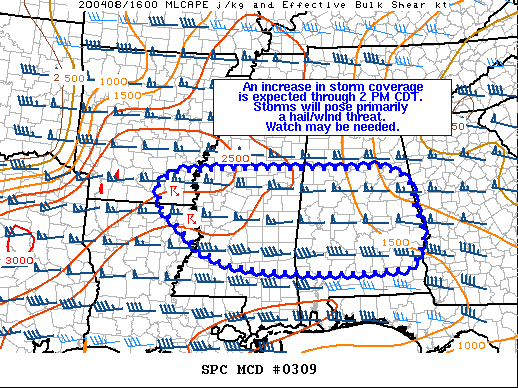
SUMMARY…
A cluster of storms moving out of southeast AR and into central MS will continue to intensify through early afternoon. Additionally, new storm development is likely across parts of central MS and AL.
DISCUSSION…
Recent satellite and radar trends show a cluster of storms moving out of southeast AR and into central MS. Although storm interactions have largely limited storm growth, a gradual increase in storm intensity is likely through the early afternoon as this cluster moves into central MS where negligible MLCIN and 1500-2000 J/kg MLCAPE are noted in recent SPC Mesoanalysis. Despite weak low-level winds, strong upper-level flow has allowed for 45-55 knots of effective bulk shear and elongated hodographs that will support organized convection, including discrete to semi-discrete modes. In this environment, these storms will pose a risk for severe hail and strong winds.
Across central AL, visible satellite imagery shows a field of agitated cumulus developing in response to boundary layer destabilization. This destabilization is being driven by modest northeastward low-level warm/moist advection and increasing daytime heating – two factors that will continue through mid afternoon. Although exact timing remains somewhat uncertain, convective initiation is expected within the next 1-2 hours. As with the AR/MS cluster of storms, any storms that develop in this region will pose a risk for hail and wind (barring destructive interactions from neighboring storms). A watch may be needed.
Category: Alabama's Weather, ALL POSTS, Severe Weather
About the Author (Author Profile)
Scott Martin is an operational meteorologist, professional graphic artist, musician, husband, and father. Not only is Scott a member of the National Weather Association, but he is also the Central Alabama Chapter of the NWA president. Scott is also the co-founder of Racecast Weather, which provides forecasts for many racing series across the USA. He also supplies forecasts for the BassMaster Elite Series events including the BassMaster Classic.Subscribe
If you enjoyed this article, subscribe to receive more just like it.


