Nice Refreshing Late Morning Across Central Alabama; A Look At Sunday’s Potential Severe Weather Threat
As of 10:20 am, we have mostly sunny skies across the area with only a few high thin clouds floating overhead. It is still rather cool out there at this time as temperatures are only in the upper 40s to the mid-60s across the area. Birmingham was at 54 degrees. The cool spot was Cullman at 46 degrees. The warm spot was Troy at 64 degrees.
Skies will remain mostly clear throughout the rest of the day and afternoon highs should reach the lower 60s to right around 70s degrees across Central Alabama from northwest to southeast. For tonight, skies will be clear and temperatures will be cold and some scattered front is possible over the northern portions of the area. Lows across Central Alabama will be in the mid-30s to the lower 40s from north to south.
NWS Huntsville just issued a FROST ADVISORY for Colbert, Cullman, DeKalb, Franklin, Jackson, Lauderdale, Lawrence, Limestone, Madison, Marshall, and Morgan counties starting Saturday at 2:00 am and set to expire at 8:00 am. Temperatures ranging from 32-36 degrees will lead to formation of frost in North Alabama.
We’ll have to wait and see if NWS Birmingham will issue a Frost Advisory for the northern counties in Central Alabama as frost looks to be possible.
Potentially Dangerous Severe Weather Event On Easter Sunday
An outbreak of severe thunderstorms appears to be likely on Sunday into Sunday night, with the greatest potential of severe storms expected from north and northeastern parts of Louisiana east-northeastward through much of the Southeast and into the Tennessee Valley. Strong to violent, long-track tornadoes, along with potentially widespread damaging wind, are possible.
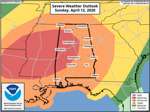
The Storm Prediction Center has introduced a MODERATE RISK (level 4 of 5) from Sunday 7:00 am to Monday 7:00 am for locations along and inside of a line from just north of Russellville (Franklin Co.) to Moulton (Lawrence Co.) to just east of Springville (St. Clair Co.) to Mountain Creek (Chilton Co.) to Whatley (Clarke Co.) to Chatom (Washington Co.) The rest of the state of Alabama has been placed in an ENHANCED RISK (level 3 of 5).
Threats in the Moderate Risk area include the potential of strong to violent tornadoes, damaging winds up to and exceeding 70 MPH, and golf ball size hail.
Threats in the Enhanced Risk area include the potential of strong tornadoes (a violent tornado can’t be ruled out), damaging winds up to 70 MPH, and quarter size hail.
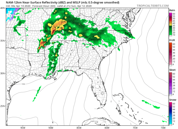
06z NAM valid Sunday 4:00 pm.
A strong, deepening surface low will be moving through the Southeast during the latter half of Easter Sunday bringing a strong cold front with it that will sweep through south of the path of the low. The low will be located around the Mississippi River in the extreme eastern parts of Arkansas at 4:00 pm and will move northeast while deepening and will be located over the north-central parts of Kentucky at 10:00 pm (based on the 06z run of the 12km NAM). A warm front will be pushing northward from the Gulf Coast and will make it through all of Alabama before the cold front arrives on Sunday evening and moves through.
We’ll have some showers and a few thunderstorms during the morning hours north of the warm front, but once the warm front approaches and passes your location, rain will come to an end. Much of the afternoon hours may be dry, but we’ll have enough energy that scattered thunderstorms may fire up in the main heating of the day. If that occurs, the atmosphere will be highly unstable and storms may quickly become strong to severe. We are also expecting several storms to form back to our west and move through the area as well. Once we lose the sunlight, we’ll also have to focus our attention on a squall line that will be moving into the state just ahead of the cold front. That line looks to move in during the late evening and push through the area and potentially exiting into Georgia after midnight.
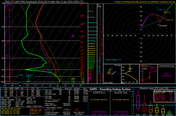
With this run of the NAM, conditions look to be the most favorable for stronger to violent tornadoes during the late evening through the late-night hours. The above sounding is valid Sunday night at 10:00 pm, showing a rare PDS Tornado threat. PDS stands for Particularly Dangerous Situation. The last time we had a PDS event was back on March 19, 2018.
We will have higher values of instability in place, along with bulk shear, helicity, and steep lapse rates. All of these ingredients together mean that storms will have the tendency to grow strong to severe rapidly and begin to rotate.
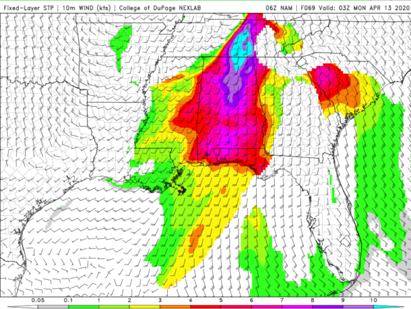
This is the Significant Tornado Parameters (STP) coming off of the same run of the NAM with this being valid Sunday night at 10:00 pm. Nearly all of the state have values of 4.0 and above with the highest values maxing out over 10.0 in the northeastern parts of the state. Birmingham has a value of over 8.0. A majority of significant tornadoes (EF-2 or greater damage) have been associated with STP values greater than 1.0 within an hour of tornado occurrence, while most non-tornadic supercells have been associated with values less than 1.0. The higher the value, the higher the potential for a strong to violent tornado to occur.
At this point, the timing for severe storms occurring for any one location across the state will be difficult to nail down as much of the activity will be mainly scattered in nature. I would start watching for the potential of storm development from as early as 1:00 pm and stay weather aware throughout the daylight hours. The main squall line may move into the northwestern corner of the state as early as 7:00 pm and move through the state and exiting into Georgia after Monday at 1:00 am.
Plain and simple… the bottom line is that all modes of severe weather are possible from Sunday afternoon through the remainder of the day until just after midnight across Central Alabama. Know where you need to be if your location goes under a warning and now is the time to get prepared. Now is the time to be sure that you have multiple trusted ways of receiving warnings as soon as they are issued. Turn the WEAs on your smartphones on as it will warn you for a tornado.
When a watch is issued, it will be a Tornado Watch. We’ll have to wait and see if we will have a PDS Tornado Watch issued. If we keep similar looks on the following high-resolution, convection-allowing model runs, I wouldn’t be surprised if the Moderate Risk will be expanded across the state and have a High Risk introduced for portions of the state by Saturday.
Please take this situation seriously. Expect your favorite TV shows to be interrupted on local TV stations due to the potential of violent tornadoes. I know it will be Easter Sunday, but please stay informed throughout the day especially the later into the day we get.
Category: Alabama's Weather, ALL POSTS, Severe Weather
About the Author (Author Profile)
Scott Martin is an operational meteorologist, professional graphic artist, musician, husband, and father. Not only is Scott a member of the National Weather Association, but he is also the Central Alabama Chapter of the NWA president. Scott is also the co-founder of Racecast Weather, which provides forecasts for many racing series across the USA. He also supplies forecasts for the BassMaster Elite Series events including the BassMaster Classic.Subscribe
If you enjoyed this article, subscribe to receive more just like it.


