Confirmed Tornadoes Over Northern Louisiana Indicative of Weather Headed Our Direction; Storms Developing Over West Alabama Now
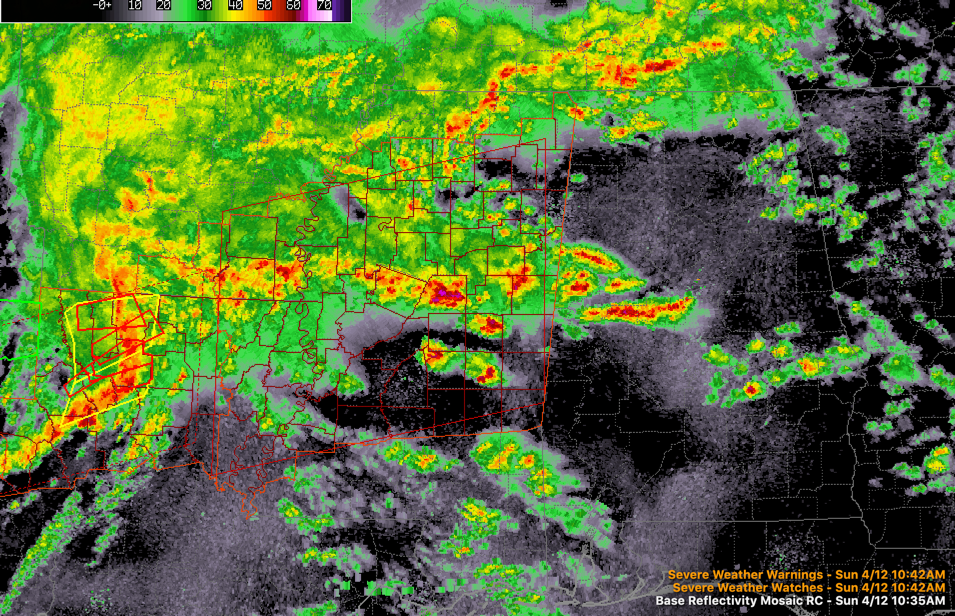
Several confirmed tornadoes have been reported on radar this morning in northern Louisiana from Shreveport down to Mansfield and up to Arcadia. There are now four tornado warnings in effect in NW Louisiana east of Shreveport.
Dangerous storms will be approaching the city of Ruston a little after 11 a.m. The storm near Ashland looks dangerous as well.
Stronger storms have developed in the past few minutes over West Alabama’s Pickens, Hale, Greene, and Bibb Counties. They are associated with the northward moving warm front that is surging across Mississippi and into western Alabama. 60F dewpoints are now found as far north at Clarksdale in the Mississippi Delta, and Meridian in eastern Mississippi. A couple of these storms could become severe as they move northward over the next few hours with hail and damaging winds possible. Can’t rule out a tornado as well.
A very strong 850 millibar jet at about 5,000 feet is developing over western Alabama and Mississippi. This will efficiently transport deep moisture and warm air northward rapidly through the afternoon. The Gulf of Mexico will really be open for business and this will be the fuel for storms, severe weather, and heavy rainfall. Winds at the surface will continue to increase outside of storms, gusting too 35-40 mph at times. Wind advisories are in effect for much of Alabama this afternoon and overnight.
A tornado watch will be coming soon for much of Mississippi. Here is the discussion from the SPC:
Probability of Watch Issuance…95 percent
SUMMARY…The severe threat will markedly increase by this
afternoon, with strong tornadoes, numerous damaging winds, and large
hail all likely. A tornado watch will be required across
northern/central MS and northeastern LA shortly.
DISCUSSION…The airmass across northeastern LA into central MS
downstream of a QLCS in northern LA is rapidly destabilizing. A warm
advection wing of elevated convection has developed across this area
as a marine warm front continues to lift northward. Surface
dewpoints are expected to quickly increase into the upper 60s to
lower 70s along/south of the northward-advancing warm front as a
strong low-level mass response occurs over the ArkLaTex region this
afternoon. With continued diurnal heating, MLCAPE should increase
into the 1500-3000 J/kg range by peak afternoon heating. Very strong
shear is forecast to be present from low through mid levels, which
will support robust storm organization both with the ongoing QLCS
and with any cells that can form farther south/east across the open
warm sector. Latest VWP from KDGX (Jackson, MS) shows substantial
low-level hodograph curvature, with 0-1 km shear approaching 50 kt,
and 0-1 SRH around 500 m2/s2. Strong tornadoes may occur given the
strength of the low-level flow, along with numerous damaging winds
if the storm mode remains mostly linear. There is still some
uncertainty regarding supercell potential across northern/central MS
this afternoon. If any storms can form farther south/east of the
ongoing QLCS, they will encounter a strongly unstable and sheared
environment favorable for all severe hazards.
Category: Alabama's Weather, ALL POSTS, Severe Weather
About the Author (Author Profile)
Bill Murray is the President of The Weather Factory. He is the site's official weather historian and a weekend forecaster. He also anchors the site's severe weather coverage. Bill Murray is the proud holder of National Weather Association Digital Seal #0001 @wxhistorianSubscribe
If you enjoyed this article, subscribe to receive more just like it.


