Tornado Watch Coming Soon To Parts Of Alabama
It probably won’t be too much longer before the Storm Prediction Center, along with NWS Birmingham and NWS Huntsville, issue a Tornado Watch for portions of the area. Here is the text from the latest Mesoscale Discussion from the Storm Prediction Center:
Probability of Watch Issuance…95 percent
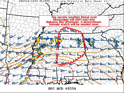
SUMMARY…
The severe weather threat currently over Mississippi will shift east into Alabama later this afternoon. A downstream tornado watch will be needed soon.
DISCUSSION…
A MCS moved across northern Louisiana this morning and produced numerous TDS signatures. This same cluster of storms has produced a TDS more recently (~1830Z) in west-central Mississippi. This same line of storms is expected to move east-northeastward into northern Alabama later this afternoon and into the evening. The airmass across northern Alabama has destabilized across the last several hours and continued moistening/warming is expected as the warm front lifts north. Therefore, this ongoing MCS is expected to maintain its current intensity and likely strengthen further as it moves into Alabama.
A 997mb meso-low has formed in southeast AR/western MS. This has acted to locally enhance the backing of surface winds ahead of these storms. This has led to very large 0-1 SRH values near 700 m2/s2 per GWX VWP. Damaging winds and QLCS tornadoes will continue to be a threat with this MCS as storms move eastward. However, there is a conditional threat for surface-based supercells to develop south of this activity in the warm sector. If this occurs, a significant, threat would become more likely.
A tornado watch will be needed soon east of the current watch in Mississippi.
Category: Alabama's Weather, ALL POSTS, Severe Weather
About the Author (Author Profile)
Scott Martin is an operational meteorologist, professional graphic artist, musician, husband, and father. Not only is Scott a member of the National Weather Association, but he is also the Central Alabama Chapter of the NWA president. Scott is also the co-founder of Racecast Weather, which provides forecasts for many racing series across the USA. He also supplies forecasts for the BassMaster Elite Series events including the BassMaster Classic.Subscribe
If you enjoyed this article, subscribe to receive more just like it.


