

EXPIRED – Severe T-Storm Warning: Blount, Etowah, Jefferson, Shelby, St. Clair Counties Until 10:30 PM
The National Weather Service in Birmingham has issued a
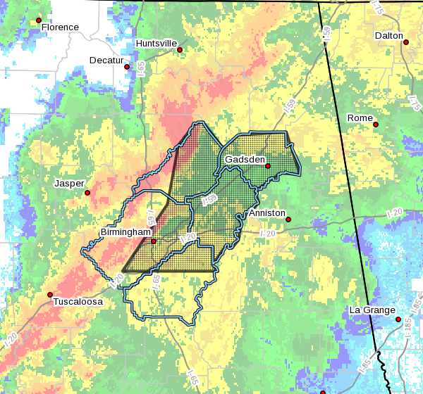
* Severe Thunderstorm Warning for…
Blount County in central Alabama…
Northeastern Shelby County in central Alabama…
Etowah County in northeastern Alabama…
Eastern Jefferson County in central Alabama…
St. Clair County in central Alabama…
* Until 1030 PM CDT.
* At 919 PM CDT, severe thunderstorms were located along a line
extending from near Strawberry to Fairview to near Dallas to
Birmingham, moving east at 45 mph.
HAZARD…60 mph wind gusts.
SOURCE…Radar indicated.
IMPACT…Expect damage to roofs, siding, and trees.
* Locations impacted include…
Birmingham, Hoover, Gadsden, Vestavia Hills, Bessemer, Homewood,
Mountain Brook, Trussville, Hueytown, Gardendale, Pell City,
Irondale, Leeds, Moody, Fairfield, Chelsea, Rainbow City,
Fultondale, Oneonta and Attalla.
PRECAUTIONARY/PREPAREDNESS ACTIONS…
A Tornado Watch remains in effect until 1000 PM CDT for central and
northeastern Alabama. A Tornado Watch also remains in effect until
midnight CDT for central and east central Alabama.
For your protection move to an interior room on the lowest floor of a
building.
Category: Alabama's Weather, ALL POSTS, Severe Weather
About the Author (Author Profile)
Scott Martin is an operational meteorologist, professional graphic artist, musician, husband, and father. Not only is Scott a member of the National Weather Association, but he is also the Central Alabama Chapter of the NWA president. Scott is also the co-founder of Racecast Weather, which provides forecasts for many racing series across the USA. He also supplies forecasts for the BassMaster Elite Series events including the BassMaster Classic.Subscribe
If you enjoyed this article, subscribe to receive more just like it.


