

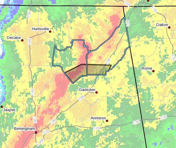
Flash Flood Warning: Marshall & Dekalb Counties Until 1:00 AM
The National Weather Service in Huntsville Alabama has issued a
* Flash Flood Warning for…
Southeastern Marshall County in northeastern Alabama…
Southwestern DeKalb County in northeastern Alabama…
* Until 100 AM CDT.
* At 954 PM CDT, Doppler radar and automated gauges indicated
thunderstorms producing heavy rain across the warned area. Up to
two inches of rain have already fallen. Flash flooding is ongoing
or expected to begin shortly.
HAZARD…Flash flooding caused by thunderstorms.
SOURCE…Radar and automated gauges.
IMPACT…Flooding of small creeks and streams, urban areas,
highways, streets and underpasses as well as other
drainage and low lying areas.
* Some locations that will experience flooding include…
Albertville, Boaz, Crossville, Douglas, McVille, High Point,
Horton, Arona, Painter and Kilpatrick.
PRECAUTIONARY/PREPAREDNESS ACTIONS…
A Flash Flood Warning means that flooding is imminent or occurring.
If you are in the warned area move to higher ground immediately.
Residents living along streams and creeks should take immediate
precautions to protect life and property.
Category: Alabama's Weather, ALL POSTS, Severe Weather
About the Author (Author Profile)
Scott Martin is an operational meteorologist, professional graphic artist, musician, husband, and father. Not only is Scott a member of the National Weather Association, but he is also the Central Alabama Chapter of the NWA president. Scott is also the co-founder of Racecast Weather, which provides forecasts for many racing series across the USA. He also supplies forecasts for the BassMaster Elite Series events including the BassMaster Classic.Subscribe
If you enjoyed this article, subscribe to receive more just like it.


