Some Strong To Damaging Winds Possible In Northwest Alabama
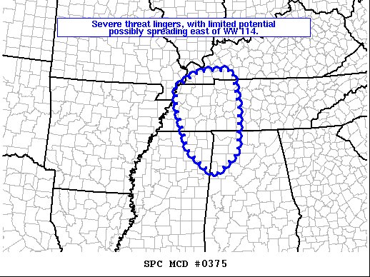
Latest Mesoscale Discussion from the Storm Prediction Center:
Areas affected…northeastern Mississippi…northwestern
Alabama…western and middle Tennessee…and western Kentucky
Concerning…Severe Thunderstorm Watch 114…
Valid 130419Z – 130545Z
The severe weather threat for Severe Thunderstorm Watch 114
continues.
SUMMARY…Local risk for damaging winds continues, and may spread
northeastward out of the WW into parts of western KY, middle TN, and
northwestern AL.
DISCUSSION…Latest radar loop shows that convection has weakened —
from a reflectivity perspective — over the past hour, with a
corresponding decrease in lightning. Still, recent reports of wind
damage have been received, as the line moves east-northeast at 55 to
60 kt.
As cold air aloft associated with the parent upper system continues
moving eastward, lingering modest instability across the middle
TN/northwestern AL may be enhanced slightly. As such, and the given
very strong flow-field aloft, some potential for a few stronger wind
gusts may linger through midnight and spread out of WW 114 into
northwestern Alabama and middle Tennessee. While at this time a new
WW is not imminent, a watch could be needed if any signs of
convective increase are observed, with the current, skeletal band of
storms.
Category: Alabama's Weather, ALL POSTS, Severe Weather
About the Author (Author Profile)
Scott Martin is an operational meteorologist, professional graphic artist, musician, husband, and father. Not only is Scott a member of the National Weather Association, but he is also the Central Alabama Chapter of the NWA president. Scott is also the co-founder of Racecast Weather, which provides forecasts for many racing series across the USA. He also supplies forecasts for the BassMaster Elite Series events including the BassMaster Classic.Subscribe
If you enjoyed this article, subscribe to receive more just like it.


