Clouds For Some While Sunny For Others At Midday
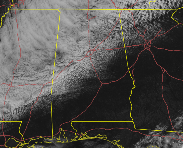
As of 11:30 am, we are still dealing with some pesky cloud cover over the northern half of the area while much of the southern half of Central Alabama has mainly clear skies and plenty of sunshine.
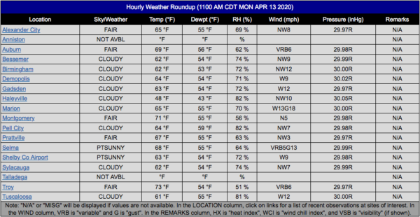
Temperatures as of the 11:00 am roundup were in the upper 40s to the lower 70s across Central Alabama. Haleyville was the cold spot at 48 degrees with cloudy skies. Troy was the warm spot at 73 degrees with fair skies. Birmingham was at 62 degrees with cloudy skies.
The good news is that those clouds will decrease throughout the remainder of the day and we’ll end up with mostly clear skies for tonight and throughout the overnight hours. Afternoon highs will range from the lower 60s in the northwestern parts of the area to the lower 80s in the southeastern parts. Lows will dip down into the lower 40s to the lower 50s.
We’ll have a mix of sun and clouds throughout the day on Tuesday and we’ll continue to have this wide spread of temperatures across Central Alabama. Afternoon highs will range from the lower 60s in the northwestern parts of the area to the lower 80s in the southeastern parts.
Both National Weather Service forecast offices (Huntsville and Birmingham) will be conducting surveys of the damage that occurred in Sunday’s severe storms. Please respect their distance if you see a member or members of the survey team out in the field as they have to adhere to the COVID-19 policy in place. As soon as we get the information on the surveys across NWS Chat, we’ll have that out to you.
Category: Alabama's Weather, ALL POSTS, Severe Weather
About the Author (Author Profile)
Scott Martin is an operational meteorologist, professional graphic artist, musician, husband, and father. Not only is Scott a member of the National Weather Association, but he is also the Central Alabama Chapter of the NWA president. Scott is also the co-founder of Racecast Weather, which provides forecasts for many racing series across the USA. He also supplies forecasts for the BassMaster Elite Series events including the BassMaster Classic.Subscribe
If you enjoyed this article, subscribe to receive more just like it.


