A 2:40 p.m. Look at the Alabama Severe Weather Situation: Warm Front Marching North
We continue to carefully monitor a developing severe weather situation across Alabama this afternoon that could bring a significant outbreak of severe weather including tornadoes to parts of our area this afternoon and evening.
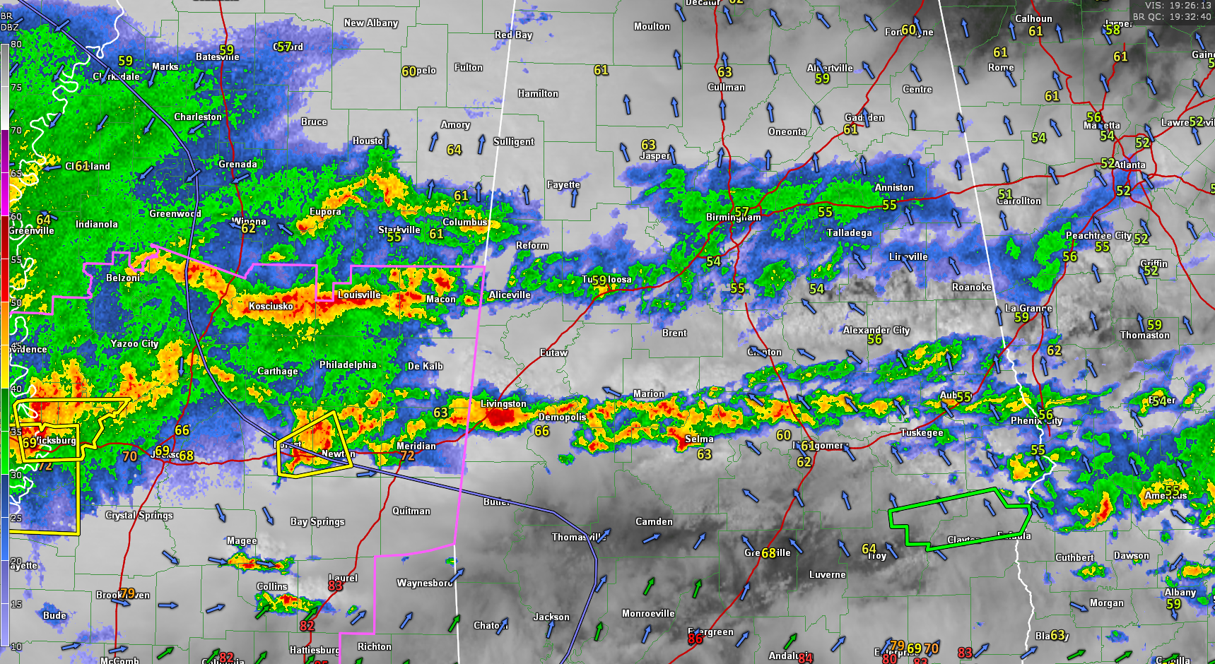
RADAR UPDATE
Rain and some thunder continue this afternoon along a rain-cooled boundary that extends from West Alabama’s Pickens County eastward through Jefferson, St. Clair, Calhoun, Cleburne, Randolph, Clay, Talladega, Shelby, Bibb, and Tuscaloosa Counties. More showers and storms are pushing north along a northward moving warm front that extends along north of the US-80 Corridor from Livingston to Marion to Selma to Wetumpka to Auburn.
Over Mississippi, stronger storms are east of the Jackson Metro. Others are between Vicksburg and Jackson. More are over Northeast Mississippi where unstable air is surging northward in response to strengthening low pressure to the west.
A developing mesoscale convective system over northern Louisiana will organize and move east-northeastward as well. This will present problems later tonight as it pushes across Mississippi and towards Alabama.
SURFACE DATA
Temperatures are now in the 80s over Southeast Louisiana, southern Mississippi, and extreme southern Alabama as well as the Florida Panhandle. Dewpoints are in the 60s and even 70s south of the warm front. This is leading to very high instabilities over the southern parts of the Gulf Coast states.
SYNOPTIC DATA
The upper trough now over Oklahoma will take on a sharply negative tilt as it moves into Arkansas over the next 12 hours, enhancing the severe weather threat over the region. Mid-level winds will increase and a strong low-level jet will ramp up over South Alabama. This strong wind shear will allow for extremely organized storms later this afternoon and overnight.
The warm front will continue moving slowly northward this afternoon, but will probably have trouble advancing past a line from Tuscaloosa to Sylacauga to Auburn. Areas to the north of the front will still have the risk of large hail and damaging winds, as well as some tornadoes, but the overall threat is less than further to the south. To the south of the warm front and in its vicinity, there is a growing risk for damaging winds and tornadoes as we progress through the afternoon hours and into the overnight.
RISK AREAS
Here are the current threats by area:
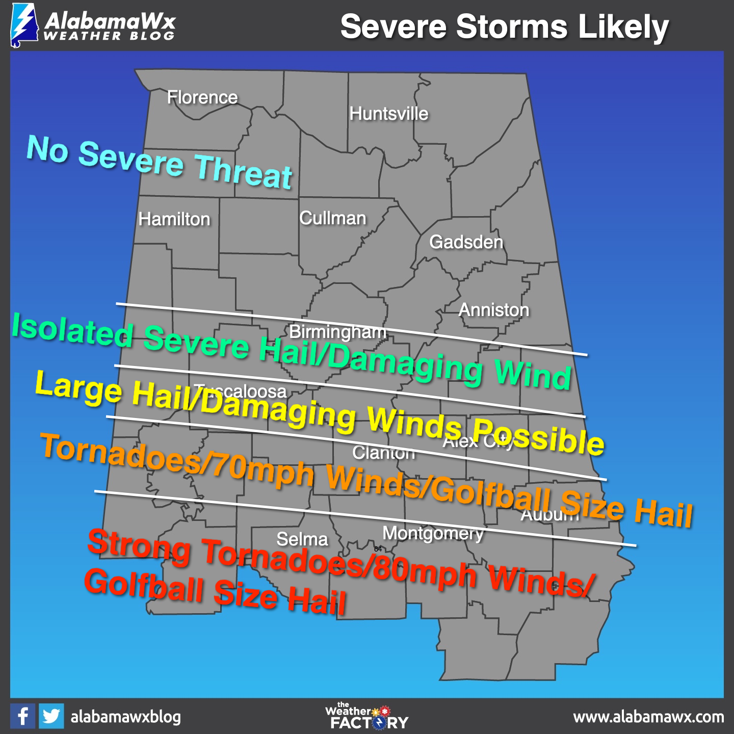
In the highest risk area near and south of a line from Demopolis to Selma to Montgomery, to just south of AUburn, strong, long tracked tornadoes may occur along with extremely high winds and very large hail. Any areas south of the warm front have the threat for tornadoes.
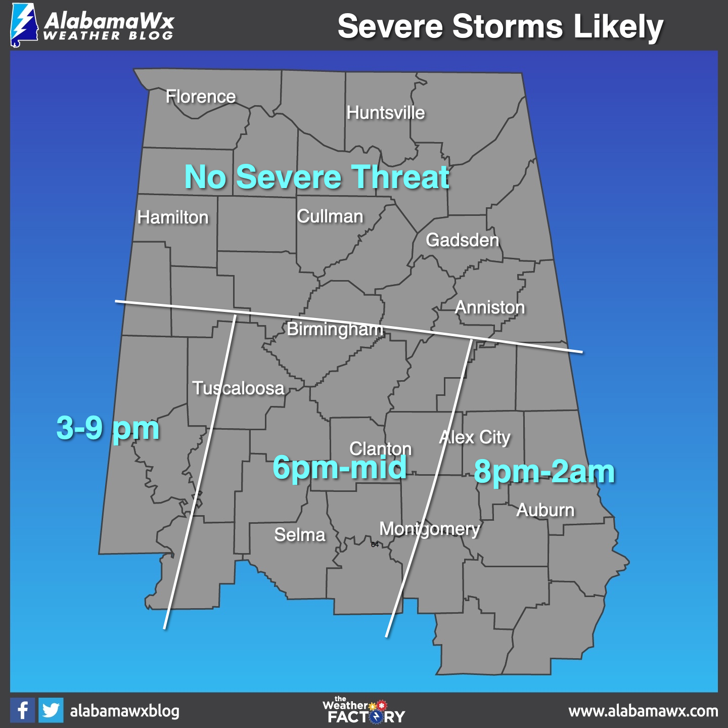
TIMING:
Here is the current timing of the threats:
RAINFALL
More heavy rainfall will fall over the next 12 hours, with 1-4 inch amounts common, and isolated 5-6 amount possible. This will obviously cause flooding in some places. Flash flood watches are in effect for much of Central and Southwest and South Alabama.

Category: Alabama's Weather, ALL POSTS
About the Author (Author Profile)
Bill Murray is the President of The Weather Factory. He is the site's official weather historian and a weekend forecaster. He also anchors the site's severe weather coverage. Bill Murray is the proud holder of National Weather Association Digital Seal #0001 @wxhistorianSubscribe
If you enjoyed this article, subscribe to receive more just like it.


