Heavy Rainfall Continues; Flash Flooding Possible
This is the latest Mesoscale Precipitation Discussion from the Weather Prediction Center:
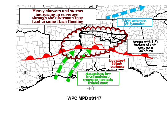
SUMMARY…
Heavy showers and thunderstorms increasing in coverage through the afternoon hours may lead to some instances of flash flooding as rainfall rates approach 2+ inches per hour where thunderstorms train over the same areas.
DISCUSSION…Regional Doppler radars are indicating an increase of intense convection over much of central Mississippi north of the warm front, with an additional round of very heavy rain approaching from the ArkLaTex region accompanied with an MCV. Moisture flux anomalies in the 700-850 MB layer are expected to be on the order of 4 standard deviations above normal, and this will lead to PWs rising into the 1.75 to 2-inch range. This will result in deep warm cloud layers and thus efficient rainfall processes. The presence of a mid-level vortmax and right entrance upper-level jet dynamics will support deep-layer ascent, and instability will also be on the increase with MLCAPE approaching 2500 J/kg near and just south of the warm front.
The latest HREF 1-hr rainfall probabilities of greater than two inches are approaching 30 percent between the Interstate 20 and Highway 82 corridors, and rainfall of this magnitude could easily exceed flash flood guidance. The latest suite of high res model guidance is suggesting the potential for localized 2 to 4-inch rainfall totals through 00Z, and it appears that the ARW2, WRF, and HRRR have the best depiction when compared to ongoing convection across the region. Locations near the Highway 82 corridor have already received 1 to 2 inches of rainfall over the past 24 hours and have thus reduced flash flood guidance and are most vulnerable to flooding with this next round of convection.
Category: Alabama's Weather, ALL POSTS, Severe Weather
About the Author (Author Profile)
Scott Martin is an operational meteorologist, professional graphic artist, musician, husband, and father. Not only is Scott a member of the National Weather Association, but he is also the Central Alabama Chapter of the NWA president. Scott is also the co-founder of Racecast Weather, which provides forecasts for many racing series across the USA. He also supplies forecasts for the BassMaster Elite Series events including the BassMaster Classic.Subscribe
If you enjoyed this article, subscribe to receive more just like it.


