It’s Breezy… It’s Beautiful… It’s The Midday Nowcast
It’s a very nice but breezy day across Central Alabama as we are making the run up to the midday hour. Skies were almost completely clear and winds were gusting as high as 20 MPH out of the west or northwest in some places. Temperatures as of the 11:00 am round-up were in the upper 60s to the mid-70s across the area. Haleyville and Gadsden were tied as the cool spots at 69 degrees. Troy was the warm spot at 76 degrees. Birmingham was sitting at 70 degrees.
We’ll continue to have near-maximum sunshine throughout the remainder of the afternoon and into the early evening hours, and we’ll also continue to have these breezy conditions until we get to sunset. Afternoon highs will range from the mid-70s to the lower-80s. Winds will calm down and we’ll have clear skies throughout the night and overnight hours. Lows will drop into the mid-40s to the lower 50s.
Wednesday will be a transitional day from nice conditions to start and end with rain and thunderstorms. We’ll start off a decent bit of sunshine, but clouds will be on the increase during the day. Once we get into the mid to late afternoon hours, we’ll have the chance of scattered showers and maybe a thunderstorm or two over the northern half of the area. Rain chances will be on the increase during the evening and overnight hours, but the stronger to severe storms look to hold off until Thursday morning after sunrise. Wednesday’s highs will be in the lower 70s to right at 80 degrees.
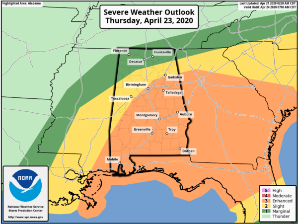
We’ll have the threat of strong to severe storms during much of the day on Thursday, with the window being from roughly around 7:00 am to 5:00 pm. A LEVEL 3 ENHANCED RISK is up for locations along and south of a line from Myrtlewood (Marengo Co.) to Brookwood (Tuscaloosa Co.) to Village Springs (Jefferson Co.) to Pleasant Gap (Cherokee Co.). A LEVEL 2 SLIGHT RISK is up from Vernon (Lamar Co.) to Vinemont (Cullman Co.) to Fort Payne (Dekalb Co.). The rest of North/Central Alabama is in a LEVEL 1 MARGINAL RISK for severe storms. Damaging winds and large hail will be the main threats, while a tornado or two is not out of the question.
As we have seen in the two previous severe weather events, severe thunderstorms with damaging winds have caused plenty of damage, some of which equals an EF-1 tornado damage. If you go under a severe thunderstorm warning, you will need to treat it as a tornado warning due to the fact that the ground is saturated and it will not take that much to start bringing trees down. We’ve seen winds over 80 MPH, and if you mix that in with large hail, some major damage can occur to your property and to the surrounding area.
This situation is still developing and the confidence is low on the tornado threat. By tomorrow, we’ll have a much better picture on what we may be dealing with. Stay tuned… be prepared… stay weather aware.
Category: Alabama's Weather, ALL POSTS, Severe Weather
About the Author (Author Profile)
Scott Martin is an operational meteorologist, professional graphic artist, musician, husband, and father. Not only is Scott a member of the National Weather Association, but he is also the Central Alabama Chapter of the NWA president. Scott is also the co-founder of Racecast Weather, which provides forecasts for many racing series across the USA. He also supplies forecasts for the BassMaster Elite Series events including the BassMaster Classic.Subscribe
If you enjoyed this article, subscribe to receive more just like it.


