Flash Flood Watch For Much Of Thursday Across Parts Of Central Alabama
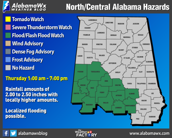
NWS Birmingham has issued a FLASH FLOOD WATCH that goes into effect at 1:00 am Thursday morning and is set to expire at 7:00 pm Thursday evening for Autauga, Bibb, Chilton, Dallas, Elmore, Greene, Hale, Lowndes, Marengo, Montgomery, Perry, Pickens, Sumter, and Tuscaloosa counties. Here is the text from NWS Birmingham:
Heavy Rain and Flash Flooding Expected Through Thursday
Showers and thunderstorms will become widespread early Thursday morning. Additional rainfall totals of 2 to 3 inches are expected to fall over already saturated soils. This could lead to flash flooding across the watch area.
* Flash Flood Watch to include a portion of central Alabama, including the following areas, Elmore and Montgomery.
* From 1 AM CDT Thursday through Thursday evening
* Heavy rainfall of two to three inches of rain may result in localized flash flooding.
A Flash Flood Watch means that conditions may develop that lead to flash flooding. Flash flooding is a very dangerous situation. You should monitor later forecasts and be prepared to take action should Flash Flood Warnings be issued.
Category: Alabama's Weather, ALL POSTS, Severe Weather
About the Author (Author Profile)
Scott Martin is an operational meteorologist, professional graphic artist, musician, husband, and father. Not only is Scott a member of the National Weather Association, but he is also the Central Alabama Chapter of the NWA president. Scott is also the co-founder of Racecast Weather, which provides forecasts for many racing series across the USA. He also supplies forecasts for the BassMaster Elite Series events including the BassMaster Classic.Subscribe
If you enjoyed this article, subscribe to receive more just like it.


