Strong Storm Affecting Madison & Limestone Counties
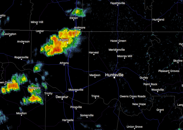
At 2:02 PM CDT, Doppler radar was tracking a strong thunderstorm near Athens, moving northeast at 55 mph. Penny size hail and winds in excess of 40 mph will be possible with this storm.
Locations impacted include…
Athens, Fayetteville, Hazel Green, Ardmore, Harvest, Lincoln,
Elkmont, Cartwright, Elkwood and Howell.
PRECAUTIONARY/PREPAREDNESS ACTIONS…
This storm may intensify, so be certain to monitor local radio
stations and available television stations for additional information
and possible warnings from the National Weather Service.
Category: Alabama's Weather, ALL POSTS, Severe Weather
About the Author (Author Profile)
Scott Martin is an operational meteorologist, professional graphic artist, musician, husband, and father. Not only is Scott a member of the National Weather Association, but he is also the Central Alabama Chapter of the NWA president. Scott is also the co-founder of Racecast Weather, which provides forecasts for many racing series across the USA. He also supplies forecasts for the BassMaster Elite Series events including the BassMaster Classic.Subscribe
If you enjoyed this article, subscribe to receive more just like it.


