A Very Late Afternoon Look At Our Weather Situation
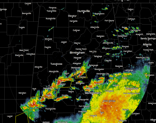
A ragged line of strong to severe thunderstorms are currently stretching from Columbiana to the southwest to Greensboro to Linden and back into the southeastern parts of Mississippi. A few severe thunderstorm warnings are in effect with this line.
We do have some instability moving in over the western and southwestern parts of the area with instability reaching at or just above 1000 J/kg. The good news is that the better helicity values are located east of these thunderstorms over the east and northeastern parts of the area. With those being displaced, the risk for a tornado is very low at this point.
For North Alabama, the cloud cover and rain-cooled air have kept the atmosphere stable and if any showers or thunderstorms move through this afternoon and evening, they will be below severe limits.
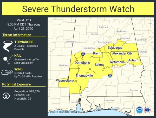
A SEVERE THUNDERSTORM WATCH continues until 9:00 pm tonight for Autauga, Bibb, Chambers, Chilton, Clay, Coosa, Dallas, Elmore, Greene, Hale, Lee, Lowndes, Marengo, Perry, Randolph, Shelby, Sumter, Talladega, and Tallapoosa counties.
The mass of rain and thunderstorms over the southeastern portions of the area has kept any severe storms from forming in those locations. Most of the energy is shunted over the Gulf Coast and along the Florida panhandle and into the extreme southern portions of Alabama and Georgia. As long as that activity stays over those locations, the chance of surface instability reaching up into our area will remain very low.
We’ll have to watch for these storms dropping large hail and isolated damaging wind gusts up to 60 MPH. Even with less than severe wind gusts, trees may fall due to the saturation of the ground.
Stay weather aware as we have a few hours left with this severe weather system.
Category: Alabama's Weather, ALL POSTS, Severe Weather
About the Author (Author Profile)
Scott Martin is an operational meteorologist, professional graphic artist, musician, husband, and father. Not only is Scott a member of the National Weather Association, but he is also the Central Alabama Chapter of the NWA president. Scott is also the co-founder of Racecast Weather, which provides forecasts for many racing series across the USA. He also supplies forecasts for the BassMaster Elite Series events including the BassMaster Classic.Subscribe
If you enjoyed this article, subscribe to receive more just like it.


