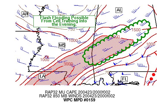
Flash Flooding Possible from Training Cells Over the Southwestern Parts of the Area
This is the latest Mesoscale Precipitation Discussion from the NWS WPC:
Areas affected…Portions of Mississippi and Alabama
Concerning…Heavy rainfall…Flash flooding possible
Valid 232143Z – 240030Z
SUMMARY…
A northeast to southwest oriented line of convection developed over parts of far eastern Mississippi into central Alabama in a region of confluent low/mid-level flow. Heavy rainfall over the past several days has left the area vulnerable to additional flash flooding due to cell training.
DISCUSSION…
Thunderstorms with locally heavy rainfall have developed in a region of low-level confluent flow. This convection formed in the wake of a larger area of thunderstorms and heavy rainfall to the south and east. With cell motion being aligned along the axis of instability…and with precipitable water values being roughly 1.5 inches along the instability axis…cells will likely be efficient rain-makers into the early evening with infall rates in excess of 1 inch per hour. Those rainfall rates are comparable with the 1-hour flash flood guidance values for the area. Total rainfall amounts of 1.5 to 2.5 inches can be expected in regions where training is most pronounced or in areas that are impacted by multiple rounds of storms.
Category: Alabama's Weather, ALL POSTS, Severe Weather
About the Author (Author Profile)
Scott Martin is an operational meteorologist, professional graphic artist, musician, husband, and father. Not only is Scott a member of the National Weather Association, but he is also the Central Alabama Chapter of the NWA president. Scott is also the co-founder of Racecast Weather, which provides forecasts for many racing series across the USA. He also supplies forecasts for the BassMaster Elite Series events including the BassMaster Classic.Subscribe
If you enjoyed this article, subscribe to receive more just like it.


