EXPIRED – Significant Weather Advisory for Cherokee Co. Until 11:30 pm
…SIGNIFICANT WEATHER ADVISORY FOR CHEROKEE COUNTY UNTIL 1130 PM
CDT…
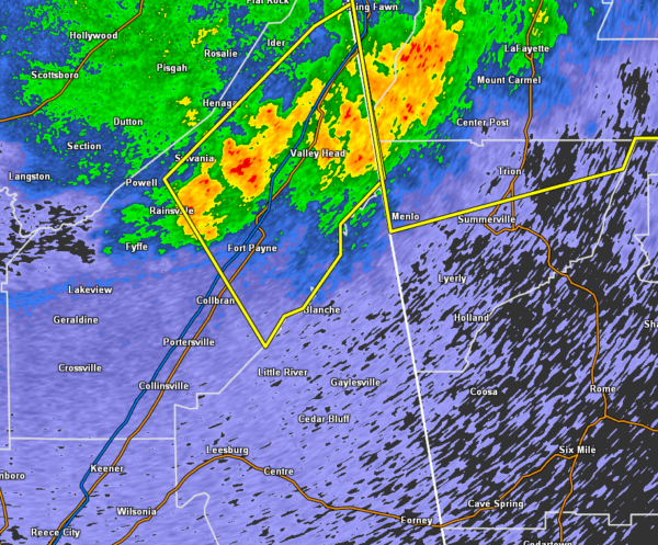
At 1044 PM CDT, Doppler radar was tracking strong thunderstorms along
a line extending from 6 miles southwest of Lafayette to near Little
River Falls to near Fyffe. Movement was southeast at 50 mph.
Wind gusts up to 50 mph will be possible with these storms.
Locations impacted include…
Centre, Cedar Bluff, Centre Municipal Airport, Little River Canyon
National Preserve, Forney, Gaylesville, Pleasant Gap, Cornwall
Furnace Park, Western Weiss Lake, Blanche, Eastern Weiss Lake,
Moshat, Little River Falls, Fullerton, New Moon, Yellow Creek Falls,
Chesnut Bay Resort, Broomtown, Howells Crossroads and Waterhouse.
PRECAUTIONARY/PREPAREDNESS ACTIONS…
To report severe weather, contact your nearest law enforcement
agency. They will relay your report to the National Weather Service
office in Birmingham.
Category: Alabama's Weather, ALL POSTS, Severe Weather
About the Author (Author Profile)
Scott Martin is an operational meteorologist, professional graphic artist, musician, husband, and father. Not only is Scott a member of the National Weather Association, but he is also the Central Alabama Chapter of the NWA president. Scott is also the co-founder of Racecast Weather, which provides forecasts for many racing series across the USA. He also supplies forecasts for the BassMaster Elite Series events including the BassMaster Classic.Subscribe
If you enjoyed this article, subscribe to receive more just like it.


