Mainly Dry At Midday, Showers/Storms May Form This Afternoon

As of 12:19 pm, there may be a few very light showers falling over the extreme northwestern and extreme eastern parts of North Alabama with the rest of the area remaining dry at this point. Temperatures as of the 12:00 pm round-up were in the lower 70s to the lower 80s across the area. Haleyville was the cool spot at 70 degrees. Troy and Montgomery were the warm spots at 83 degrees. Birmingham was sitting at 79 degrees. Those afternoon highs should reach the upper 70s to the upper 80s across Central Alabama from northwest to southeast.
We’ll partly to mainly cloudy skies across the area today with a chance of showers and thunderstorms forming during the afternoon and early evening hours. We may see a stronger storm or two with gusty winds and some hail, and possibly a severe thunderstorm warning or two may be issued if any storms become strong enough.
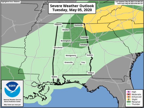
A LEVEL 2 SLIGHT RISK for severe storms is up for the extreme northeastern corner of the state which includes locations east of a line from Bridgeport to Pisgah (both in Jackson Co.) to Valley Head (Dekalb Co.).
A LEVEL 1 MARGINAL RISK for severe storms is up for locations east of a line from Lester (Limestone Co.) to Natural Bridge (Winston Co.) to Coker (Tuscaloosa) and north of a line from Coker to Calera (Shelby Co.) to New Site (Tallapoosa Co.) to Just north of Rock Mills Randolph Co.).
The main threat window across North/Central Alabama will be from 11:00 am to 4:00 pm in the North Alabama counties and from 2:00 pm to 9:00 pm in the Central Alabama counties. While the overall threat is conditional on what can fire up with the heating of the day, we still have the possibility of a few damaging wind gusts up to 60 MPH and hail up to quarter size occurring with any storm that can grow to severe criteria. A brief tornado may be possible in the Slight Risk locations, but not likely.
A cold front will be pushing south-southeastward through the area today during the main heating which may provide enough lift for showers and thunderstorms to develop. The good news is that we are lacking on some of the ingredients for this to be a larger threat: shear, helicity, moisture. The bad news is that there will be plenty of instability available for storms to form and persists once they do form.
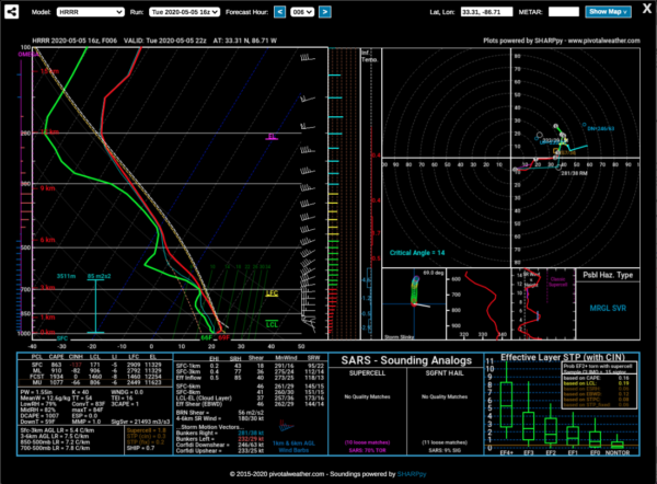
The latest forecast soundings from the 16z run of the HRRR for the Birmingham metropolitan area show that there will be a decent cap in place to keep storms below severe limits. Shear will only be around 36 knots which just makes it into the lowest end of severe storms being possible. Helicity will only be around 77 m2/s2 which is way less than the 250 m2/s2 needed to support rotating updrafts. However, downdraft CAPE is topping out at over 1000 J/kg which is more than enough to supports strong winds reaching the surface. We also have relatively steep lapse rates maxing out around 7.8ºC/km which would support strong updrafts capable of producing hail. This verifies with the SPC risk level for much of the area.
This sounding also shows that Birmingham would need to hit at least 83 degrees for convection to start occurring. At this point, the afternoon highs is only forecast to reach 80 degrees for the Magic City. This would verify with the conditional threat. If we happen to get a few more breaks in the clouds and we’re able to reach 83 degrees, we should see strong storms forming. By the way, our potential high if we were to get clearing would be 84 degrees according to the sounding.
Nearly all of the activity looks to be over by the late local news or just after tonight as the cold front will have made it to the south-southeast of the southern-most counties of Central Alabama. A few light stray showers may remain just behind the front, but with the lack of moisture, that doesn’t appear to be likely. Overnight lows will be right at 50 degrees in the north to right around 60 degrees in the south.
Category: Alabama's Weather, ALL POSTS, Severe Weather
About the Author (Author Profile)
Scott Martin is an operational meteorologist, professional graphic artist, musician, husband, and father. Not only is Scott a member of the National Weather Association, but he is also the Central Alabama Chapter of the NWA president. Scott is also the co-founder of Racecast Weather, which provides forecasts for many racing series across the USA. He also supplies forecasts for the BassMaster Elite Series events including the BassMaster Classic.Subscribe
If you enjoyed this article, subscribe to receive more just like it.


