

Invest 90L Has Become Much Better Organized and is Now Tropical Depression One
SUMMARY OF 500 PM EDT…2100 UTC…INFORMATION
———————————————-
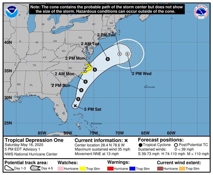
LOCATION…28.4N 78.6W
ABOUT 125 MI…200 KM E OF MELBOURNE FLORIDA
ABOUT 505 MI…810 KM SSW OF CAPE HATTERAS NORTH CAROLINA
MAXIMUM SUSTAINED WINDS…35 MPH…55 KM/H
PRESENT MOVEMENT…NNE OR 20 DEGREES AT 13 MPH…20 KM/H
MINIMUM CENTRAL PRESSURE…1008 MB…29.77 INCHES
WATCHES AND WARNINGS
——————–
A Tropical Storm Watch has been issued for the North Carolina coast from north of Surf City to Duck, including Pamlico and Albemarle Sounds.
A Tropical Storm Watch is in effect for…
* New River Inlet to Duck NC
* Pamlico and Albemarle Sounds
A Tropical Storm Watch means that tropical storm conditions are possible within the watch area, generally within 48 hours.
DISCUSSION AND OUTLOOK
———————-
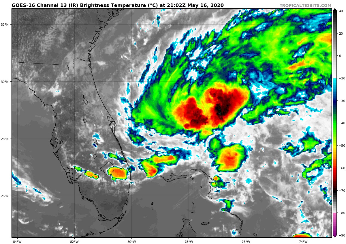
At 500 PM EDT (2100 UTC), the center of Tropical Depression One was located near latitude 28.4 North, longitude 78.6 West. The depression is moving toward the north-northeast near 13 mph (20 km/h) and this motion should continue during the next day or so. After that time, a faster northeastward motion is expected. On the forecast track, the depression is expected to move offshore, but parallel to, the coast of Florida tonight, and then move near or east of the coast of North Carolina on Monday.
Maximum sustained winds are near 35 mph (55 km/h) with higher gusts. Gradual strengthening is forecast, and the depression is expected to become a tropical storm on Sunday.
The estimated minimum central pressure based on surface observations and earlier aircraft reconnaissance data is 1008 mb (29.77 inches).
HAZARDS AFFECTING LAND
———————-
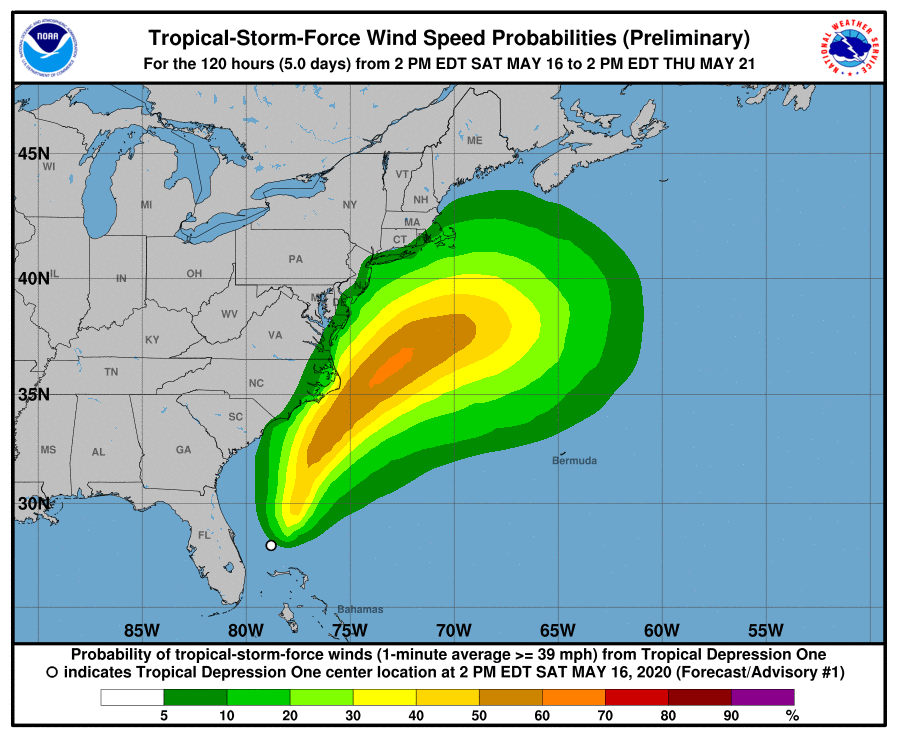
WIND: Tropical storm conditions are possible within the watch area by on Monday.
RAINFALL: The depression is expected to produce additional rain accumulations of 1 to 2 inches over the central and northwest Bahamas, and generally less than 1 inch over south Florida through tonight. The depression is also expected to produce total rain accumulations of 1 to 2 inches over coastal North Carolina Sunday night and Monday.
SURF: Swells generated by the depression are affecting portions of the east coast of central and northern Florida. These swells are expected to spread northward during the next few days and could cause life-threatening surf and rip current conditions across much of the U.S. southeast and mid-Atlantic coasts. Please consult products from your local weather office.
About the Author (Author Profile)
Scott Martin is an operational meteorologist, professional graphic artist, musician, husband, and father. Not only is Scott a member of the National Weather Association, but he is also the Central Alabama Chapter of the NWA president. Scott is also the co-founder of Racecast Weather, which provides forecasts for many racing series across the USA. He also supplies forecasts for the BassMaster Elite Series events including the BassMaster Classic.Subscribe
If you enjoyed this article, subscribe to receive more just like it.


