

Sunday Weather Xtreme: Showers, Some Storms Through Monday; TS Arthur Stays Well to our East
An early-season tropical storm in the Atlantic, significant short term dryness across Alabama, and a weatherman’s woe: a May upper level low are all stars in this week’s forecast package. Let’s dig into the details.
NICE START TO OUR SUNDAY: Under partly cloudy skies, temperatures across North and Central Alabama are in the middle and upper 60s. Dewpoints are climbing through the 60s. Clouds will increase through the day, and so will temperatures, reaching the upper 80s by afternoon.
ON THE WEATHER MAPS: A large trough of low pressure is crashing into the Pacific Northwest. Ahead of it, a ridge is over the Rockies, with a trough over the Central Plains, centered from Iowa to Texas. There are two lost upper lows wandering in the wilderness, one over Iowa, and another over Arkansas. These lows are accompanied by surface lows near Des Moines and Texarkana. Just off the Southeast Coast, we find Tropical Storm Arthur, which received a name this morning.
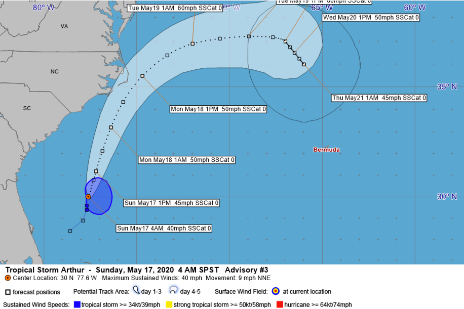
CAUGHT BETWEEN THE MOON AND NEW YORK CITY this morning, Arthur is a minimal tropical storm with top winds of 40 mph, located some 120 miles east northeast of Jacksonville, Florida. It will only slowly intensify over the next 24 hours, reaching an intensity of 50 mph early Monday morning while a little less than 100 miles south of Cape Hatteras. After passing the Outer Banks of North Carolina, the system will turn more east northeast and slow down through Wednesday. Peak intensity will probably occur Tuesday as it passes back over the Gulfstream, when winds are forecast to reach 60 mph.
SHOWERS AND STORMS ON THE INCREASE: We need the rain for sure, but unfortunately, not much is on the way. As the trough pushes east over the next 24 hours and the surface low moves to near Chicago by tomorrow, showers and storms will slowly increase across Alabama. Scattered showers and storms will move across the state this afternoon. There will be plenty of instability, but little wind shear, so storm organization will be weak. It will be warm and humid overnight with lows in the middle 60s. More showers and storms will form on Monday ahead of the cold front which will push through the state by Monday night. Monday highs will be around 80F. Dewpoints will drop behind the front, and lows by Tuesday morning will be in the lower and middle 50s.
NICE MIDWEEK RUN: A big upper level low will drop to near Nashville by Wednesday. Some wraparound cloudiness and showers could affect Alabama, but cool temperatures are definitely in the offing. Lows will be in the 50s each morning through Thursday. Highs will be in the middle 70s Tuesday, upper 70s Wednesday, and lower 80s Thursday.
WEEKEND OUTLOOK: The holiday weekend looks dry for the most part. Highs will be in the upper 80s. Lows in the upper 60s.
BEACHCAST: Showers and storms are in the forecast through tomorrow along the beautiful beaches of Alabama and Northwest Florida. The rest of the week will be beautiful with highs in the middle 80s and lows in the upper 60s. Water temperatures are in the middle 70s.
Click here to see the Beach Forecast Center page.
NATIONALLY: Flash flood watches cover a wide area from Northeast Texas to the Great Lakes states this morning. Out west, numerous wind advisories, fire weather watches, and red flag warnings are in effect. Winter storm watches cover the northern Sierra Mountains in California, where high elevation snows will make travel difficult through the mountain passes.
ADVERTISE WITH US: Deliver your message to a highly engaged audience by advertising on the AlabamaWX.com website. The site enjoyed 17.2 MILLION pageviews in the past 12 months. Don’t miss out! We can customize a creative, flexible and affordable package that will suit your organization’s needs. Contact me, Bill Murray, at (205) 687-0782 and let’s talk.
WEATHERBRAINS: This week, the panel will entertain Robbie Berg from the National Hurricane Center. Check out the show at www.WeatherBrains.com. You can also subscribe on iTunes. You can watch the show live at live.bigbrainsmedia.com or on James’ YouTube Channel You will be able to see the show on the James Spann 24×7 weather channel on cable or directly over the air on the dot 2 feed.
ON THIS DATE IN 2013: Most of the night and into the following morning, heavy showers and thunderstorms continued to train over the same areas of East Alabama. Rainfall estimates were anywhere from 3-10 inches of rain depending on location. Numerous flash flood warnings were issued and flood warnings were issued for the Tallapoosa River. From eastern Jefferson County to the east along Interstate 20 to the Georgia state line and points to the south, there were reports of numerous roads impassable because of floodwaters. Several roads around Mt. Cheaha were washed out. Follow my weather history tweets on Twitter. I am @wxhistorian at Twitter.com.
Category: Alabama's Weather, ALL POSTS
About the Author (Author Profile)
Bill Murray is the President of The Weather Factory. He is the site's official weather historian and a weekend forecaster. He also anchors the site's severe weather coverage. Bill Murray is the proud holder of National Weather Association Digital Seal #0001 @wxhistorianSubscribe
If you enjoyed this article, subscribe to receive more just like it.


