Sunday Weather Xtreme: Warm, Humid, Scattered Showers/Storms; Rinse/Repeat
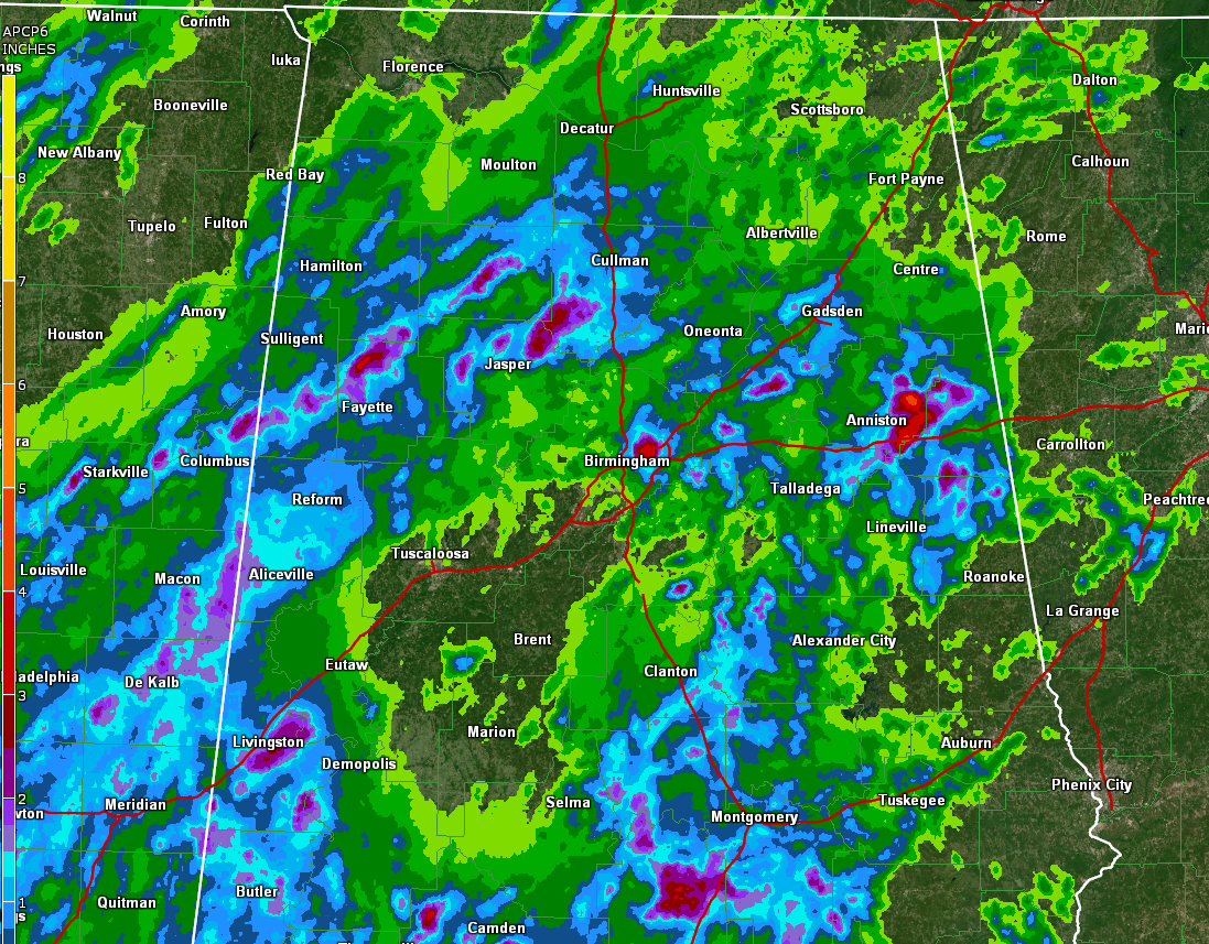
Sunday was stormy across much of Central Alabama as an unstable airmass erupted into thunderstorms for the second straight day. Some of the storms were strong and even severe. One of the storms produced a 42 mph wind gust at the Shuttlesworth Birmingham International Airport shortly after 6 p.m. In addition, 2.01 inches of rain fell in just an hour, and when an approaching outflow boundary from the west, energizing more cells, nearly another inch fell in the following hour. A half dozen severe thunderstorms were issued. The storms slowly weakened during the late evening as they pushed eastward.
ON THE WEATHER MAPS: Upper ridge over the southeastern states, trough over the western Rockies, trough over the Northeast. Surface high pressure ridge along the Appalachians, low pressure from Texas to Kansas. Deep moisture extends from the Gulf of Mexico, being transported northward from the Gulf of Mexico by southerly low level winds. A summertime pattern has developed with daytime heating triggering
FOR YOUR SUNDAY: we’re starting off with partly to mostly cloudy skies this morning across Central Alabama, thanks to abundant low level moisture and leftover cloudiness from last evening’s convection. Our warm, spring sun will burn through it this morning, sending the mercury rising toward the upper 80s to near 90F for later this afternoon. Scattered thunderstorms should once again develop during the afternoon as instability levels produce plenty of rising air for thunderstorm updrafts. Wind patterns are weak, so pulse thunderstorms will be the storm mode, which will mean rapid development, quick collapse, and the potential for gusty and even occasionally damaging winds in any stronger downbursts. Be alert for a darkening sky and be prepared to take shelter if a storm develops near you because they will also produce deadly lightning. High moisture levels will make brief heavy rain a good bet as well.
MEMORIAL DAY: Tomorrow looks a lot like today with plenty of heat and humidity, and the chance for scattered afternoon showers and storms to develop and last into the evening. Look for the same potential hazards from the sky as we will see today.
RINSE AND REPEAT: It’s basically a rinse and repeat forecast with the trough remaining to our west through the end of the week, giving us warm and humid and allowing daytime heating and passing disturbances to trigger afternoon and evening storms. Highs will be in the middle and upper 80s each day. Lows will bee in the upper 60s.
WHAT ABOUT THE WEEKEND? More showers and storms for Friday and Saturday as a weak frontal boundary tries to push through. It might actually succeed y Sunday, perhaps giving us a respite from the precipitation. But don’t look for a cool down any time soon.
VOODOO TERRITORY: Most of the following week will be dry, except for June 5th and 5th (Friday/Saturday) which could see another round of showers and storms with another front.
TROPICS: Don’t be surprised if some little tropical depression type low forms over the southeastern Gulf of Mexico and tracks across South Florida later today or Monday. And keep an eye on the western Caribbean around the weekend of the 6th/7th. There are indications a tropical storm could come out of there heading for the southeastern Gulf, South Florida, or the Bahamas.
BEACHCAST: rain is in the forecast each day along the beautiful beaches of Alabama and Northwest Florida this week. But as always say, a day at the beach in the rain is better than any day anywhere else. It will only rain an hour or two each day and the sun will be out some too. Highs will be in the middle 80s and lows in the lower 70s.
Click here to see the Beach Forecast Center page.
WEATHERBRAINS: This week, the panel will entertain Chris Darden and Kevin Laws from the National Weather Service in Birmingham. . Check out the show at www.WeatherBrains.com. You can also subscribe on iTunes. You can watch the show live at live.bigbrainsmedia.com or on James’ YouTube Channel You will be able to see the show on the James Spann 24×7 weather channel on cable or directly over the air on the dot 2 feed.
ON THIS DATE IN 1973: The Union City OK tornado was the first storm to be studied in detail by the National Severe Storms Laboratory Doppler Radar Unit at Norman, OK, and an armada of researchers. Research of the radar data from the storm would lead to discovery of the TVS – or Tornado Vortex Signature. The presence of a TVS on Doppler radar data is a very strong indication of tornadic potential in a severe thunderstorm. Follow my weather history tweets on Twitter. I am @wxhistorian at Twitter.com.
Category: Alabama's Weather, ALL POSTS
About the Author (Author Profile)
Bill Murray is the President of The Weather Factory. He is the site's official weather historian and a weekend forecaster. He also anchors the site's severe weather coverage. Bill Murray is the proud holder of National Weather Association Digital Seal #0001 @wxhistorianSubscribe
If you enjoyed this article, subscribe to receive more just like it.


