Strong Storms Affecting Talladega & Shelby Co.
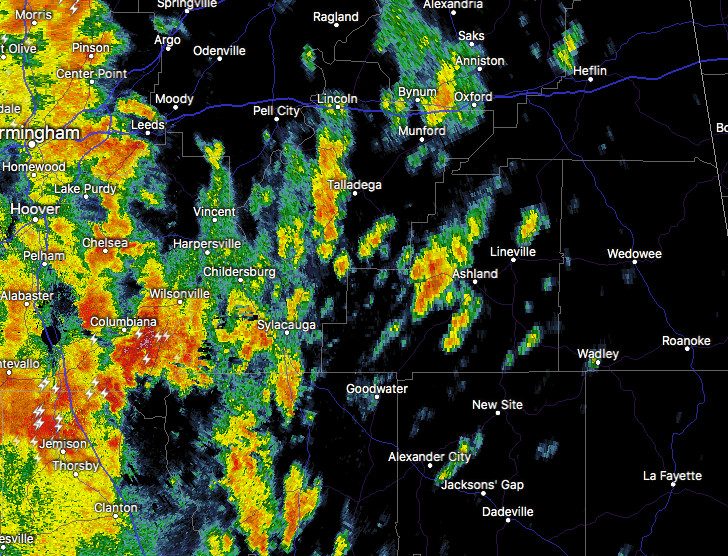
…SIGNIFICANT WEATHER ADVISORY FOR SOUTHWESTERN TALLADEGA AND
SOUTHEASTERN SHELBY COUNTIES UNTIL 430 PM CDT…
At 352 PM CDT, Doppler radar was tracking a strong thunderstorm over
Columbiana. This storm was nearly stationary.
Pea size hail and winds in excess of 40 mph will be possible with
this storm.
Locations impacted include…
Columbiana, Wilsonville, Talladega Springs, Harpersville,
Fayetteville, Lay Lake, Shelby, Beeswax Creek Park, Alabama 4H
Center, Shelby Shores, Cedar Creek, Highway 145 and CR 46, Kelley
Branch, Varnons, Spring Creek and Gaston Steam Plant.
PRECAUTIONARY/PREPAREDNESS ACTIONS…
Torrential rainfall is also occurring with this storm, and may lead
to localized flooding. Do not drive your vehicle through flooded
roadways.
Category: Alabama's Weather, ALL POSTS, Severe Weather
About the Author (Author Profile)
Scott Martin is an operational meteorologist, professional graphic artist, musician, husband, and father. Not only is Scott a member of the National Weather Association, but he is also the Central Alabama Chapter of the NWA president. Scott is also the co-founder of Racecast Weather, which provides forecasts for many racing series across the USA. He also supplies forecasts for the BassMaster Elite Series events including the BassMaster Classic.Subscribe
If you enjoyed this article, subscribe to receive more just like it.


