Cristobal Heading Northward; Alabama Gulf Coast Placed Under a Tropical Storm Watch
SUMMARY OF 1000 AM CDT…1500 UTC…INFORMATION
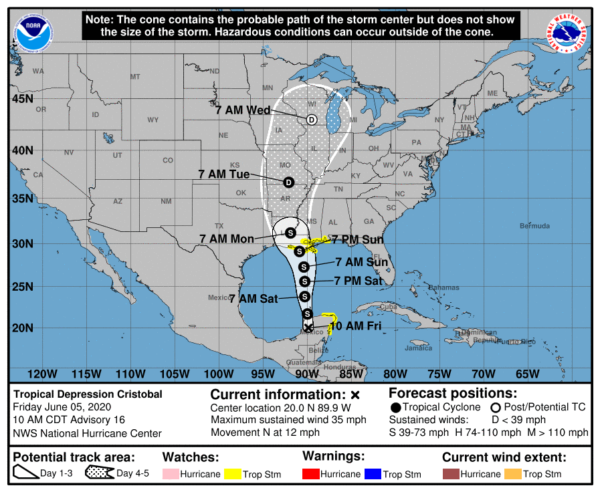
LOCATION…20.0N 89.9W
ABOUT 40 MI…65 KM E OF CAMPECHE MEXICO
MAXIMUM SUSTAINED WINDS…35 MPH…55 KM/H
PRESENT MOVEMENT…N OR 360 DEGREES AT 12 MPH…19 KM/H
MINIMUM CENTRAL PRESSURE…1000 MB…29.53 INCHES
WATCHES AND WARNINGS
A Storm Surge Watch has been issued for the northern Gulf of Mexico coast from Indian Pass to Arepika, Florida, and from Grand Isle, Louisiana, to Ocean Springs, Mississippi, including Lake Borgne.
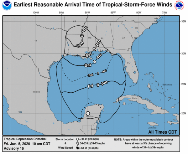
A Tropical Storm Watch has been issued for the northern Gulf of Mexico coast from Intracoastal City Louisiana to the Alabama/Florida border, including Lake Pontchartrain and Lake Maurepas.
A Storm Surge Watch means there is a possibility of life-threatening inundation, from rising water moving inland from the coastline, in the indicated locations during the next 48 hours.
A Tropical Storm Watch means that tropical storm conditions are possible within the watch area, generally within 48 hours. Tropical storm conditions in the watch area in Mexico could occur through this afternoon.
DISCUSSION AND OUTLOOK
At 1000 AM CDT (1500 UTC), the center of Tropical Depression Cristobal was located near latitude 20.0 North, longitude 89.9 West. The depression is moving toward the north near 12 mph (19 km/h), and this general motion is expected to continue for the next couple of days. On the forecast track, the center will move back over the southern Gulf of Mexico this evening, over the central Gulf of Mexico on Saturday, and be near the northern Gulf of Mexico coast Sunday evening.
Maximum sustained winds are near 35 mph (55 km/h) with higher gusts. Some strengthening is forecast during the next 48 hours, and Cristobal is expected to regain tropical storm strength later today. Some additional strengthening is forecast thereafter.
The estimated minimum central pressure is 1000 mb (29.53 inches).
HAZARDS AFFECTING LAND
STORM SURGE: The combination of a dangerous storm surge and the tide will cause normally dry areas near the coast to be flooded by rising waters moving inland from the shoreline. The water could reach the following heights above ground somewhere in the indicated areas if the peak surge occurs at the time of high tide…
Aripeka to Marco Island including Tampa Bay…1-3 ft
Grand Isle to Ocean Springs including Lake Borgne…2-4 ft
Indian Pass to Aripeka…2-4 ft
Ocean Springs to Indian Pass including Mobile Bay and Pensacola Bay…1-3 ft
The deepest water will occur along the immediate coast in areas of onshore winds and will likely extend along the coast well to the east of the center. Surge-related flooding depends on the relative timing of the surge and the tidal cycle and can vary greatly over short distances.
WIND: Tropical storm conditions are possible today within the Tropical Storm Watch area of the Yucatan Peninsula. Tropical storm conditions are possible within the Tropical Storm Watch area of the northern Gulf coast beginning early Sunday.
RAINFALL: Cristobal is expected to produce the following rain accumulations:
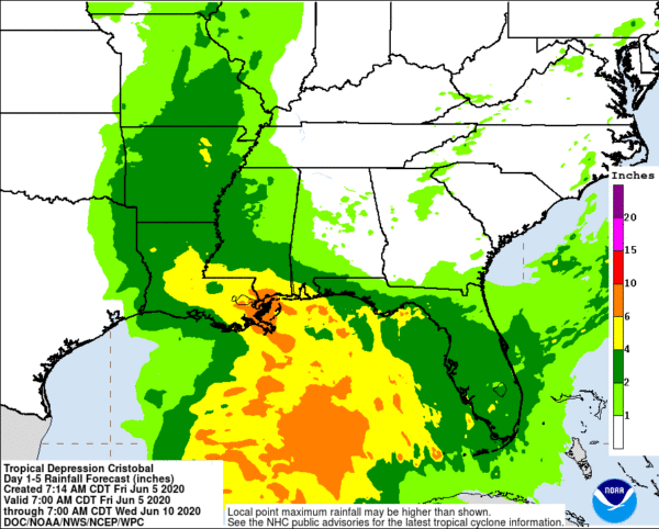
Through Wednesday morning, for portions of the eastern and central Gulf Coast and the Lower Mississippi Valley, rainfall accumulations of 4 to 8 inches, with local amounts to 12 inches, are forecast. Isolated significant river flooding is possible along the central Gulf Coast. Farther north across the Mid-Mississippi Valley, rainfall totals of 2 to 4 inches, with local amounts to 6 inches, are expected. Rises along smaller-order streams are possible across the Mid-Mississippi Valley. This degree of rainfall is expected to lead to flash flooding.
Mexican states of Campeche, Quintana Roo, and Yucatan…Additional 4 to 6 inches, isolated storm totals of 25 inches.
Belize and the Mexican states of Tabasco and Oaxaca…Additional 4 to 6 inches, isolated storm totals of 12 inches.
Southern Guatemala, coastal portions of Chiapas, and El Salvador…Additional 4 to 6 inches, isolated storm total amounts of 35 inches dating back to Saturday, May 30th.
Southern parts of Honduras…Additional 3 to 4 inches, isolated 8 inches.
Rainfall across Southeast Mexico and northern Central America would continue the risk of life-threatening flash floods and mudslides.
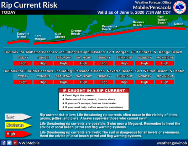
SURF: Swells generated by Cristobal will affect portions of the northern and eastern Gulf coast during the next few days. These swells are likely to cause life-threatening surf and rip current conditions.
Category: Alabama's Weather, ALL POSTS, Tropical


