Cristobal Weakens to a Depression, Strong Winds Along with Inland & Coastal Flooding Continue
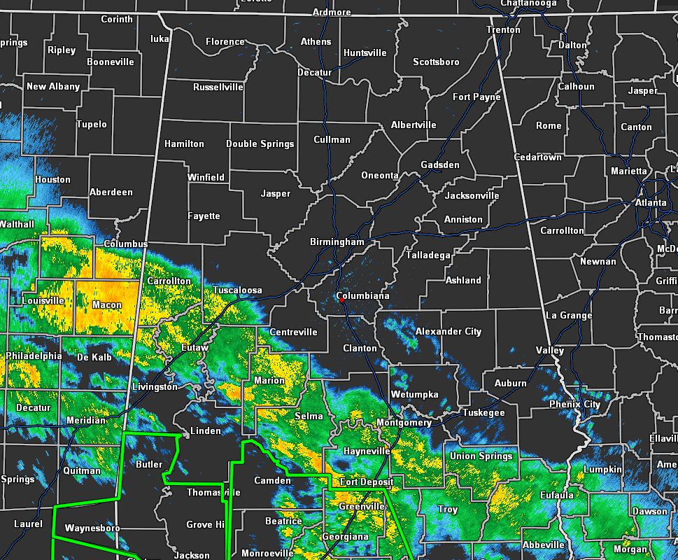
As of 4:40 am, Cristobal continues to move farther inland over Louisiana with the outer rain bands now affecting the southern and southwestern parts of Central Alabama mainly from Reform to Prattville to Eufaula. The good news is that other than light to moderate rainfall with this first band, we do not have any rotational markers showing up at this time.
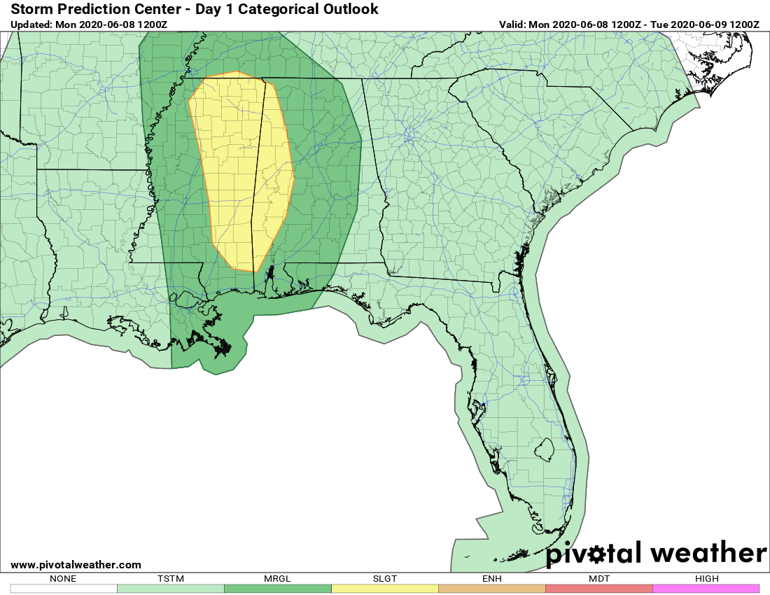
We do have a Slight Risk (level 2) up for the western parts of the area west of a line from Uniontown (Perry Co.) to Windham Springs (Bibb Co.) to Phil Campbell (Franklin Co.) to Waterloo (Lauderdale Co.) throughout the day today, along with a Marginal Risk (level 1) that covers nearly the rest of the area. Locations east of a line stretching from Scottsboro (Jackson Co.) to Heflin (Cleburne Co.) to Tuskegee (Macon Co.) to Antioch (Pike Co.) are not in a risk for severe storms at this time.
We could see a few isolated damaging wind gusts up to 60 MPH and a brief tropical-type spin-up tornado or two within the risk areas with the main window being from now through 9:00 pm tonight.
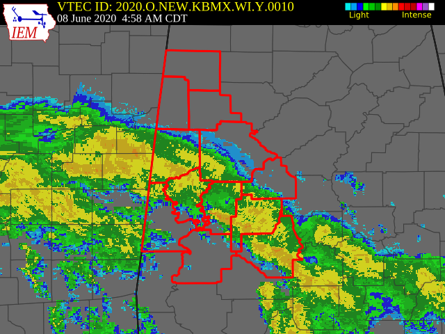
Wind Advisories are up until 7:00 pm tonight for Bibb, Dallas, Fayette, Greene, Hale, Lamar, Marengo, Marion, Perry, Pickens, Sumter, and Tuscaloosa counties in Central Alabama.
TD CRISTOBAL: CURRENT WATCHES AND WARNINGS
A Storm Surge Warning is in effect for…
* Mouth of the Mississippi River to Ocean Springs Mississippi
* Lake Borgne
STORM INFORMATION
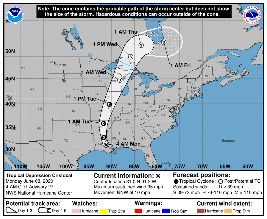
• Center is about 40 miles N OF Baton Rouge, LA
• 31.0N 91.2W
• Storm Intensity 35 MPH
• Movement NNW or 330 degrees at 10 MPH
SITUATION OVERVIEW
At 400 AM CDT (0900 UTC), the center of Tropical Depression Cristobal was located near latitude 31.0 North, longitude 91.2 West. The depression is moving toward the north-northwest near 10 mph (17 km/h) and this motion should continue with some increase in forward speed today. A turn toward the north is expected tonight, followed by a north-northeast motion and a faster forward speed Tuesday through Wednesday. On the forecast track, the center of Cristobal should move through southwestern Mississippi and northeastern Louisiana today, through Arkansas and eastern Missouri tonight and Tuesday, and reach Wisconsin and the western Great Lakes by Wednesday.
Maximum sustained winds have decreased to near 35 mph (55 km/h) with higher gusts. Additional weakening is expected through Tuesday. However, Cristobal is expected to strengthen some as it becomes an extratropical low Tuesday night and Wednesday.
The estimated minimum central pressure based on surface observations is 994 MB (29.36 inches).
HAZARDS AFFECTING LAND
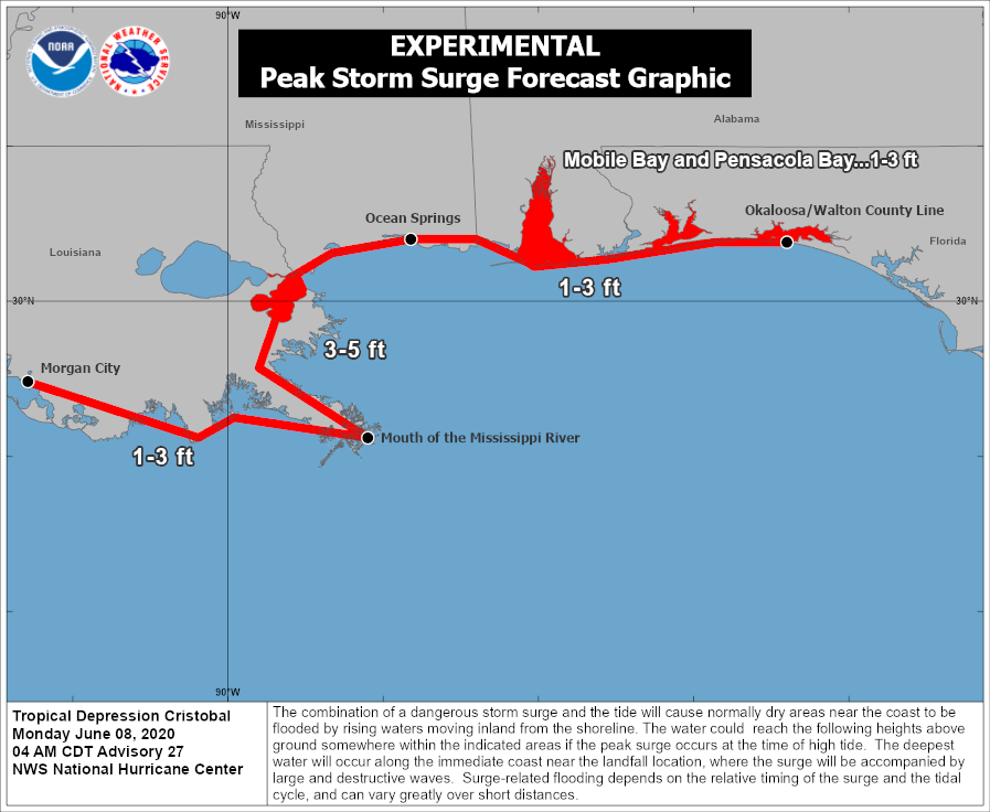
STORM SURGE: The combination of a dangerous storm surge and the tide will cause normally dry areas near the coast to be flooded by rising waters moving inland from the shoreline. The water could reach the following heights above ground somewhere in the indicated areas if the peak surge occurs at the time of high tide…
Mouth of the Mississippi River to Ocean Springs MS including Lake Borgne…3-5 ft
Morgan City LA to Mouth of the Mississippi River…1-3 ft
Ocean Springs MS to Okaloosa/Walton County Florida line, including
Mobile Bay and Pensacola Bay…1-3 ft
The deepest water will occur along the immediate coast in areas of onshore winds and will likely extend along the coast well to the east of the center. Surge-related flooding depends on the relative timing of the surge and the tidal cycle and can vary greatly over short distances. For information specific to your area, please see products issued by your local National Weather Service forecast office.
WIND: Wind gusts to tropical-storm-force are expected this morning over portions of the northern Gulf coast from southeastern Louisiana to the western Florida Panhandle. Gusty winds could also occur Tuesday night and Wednesday over portions of the Midwest and western Great Lakes as Cristobal becomes an extratropical low.
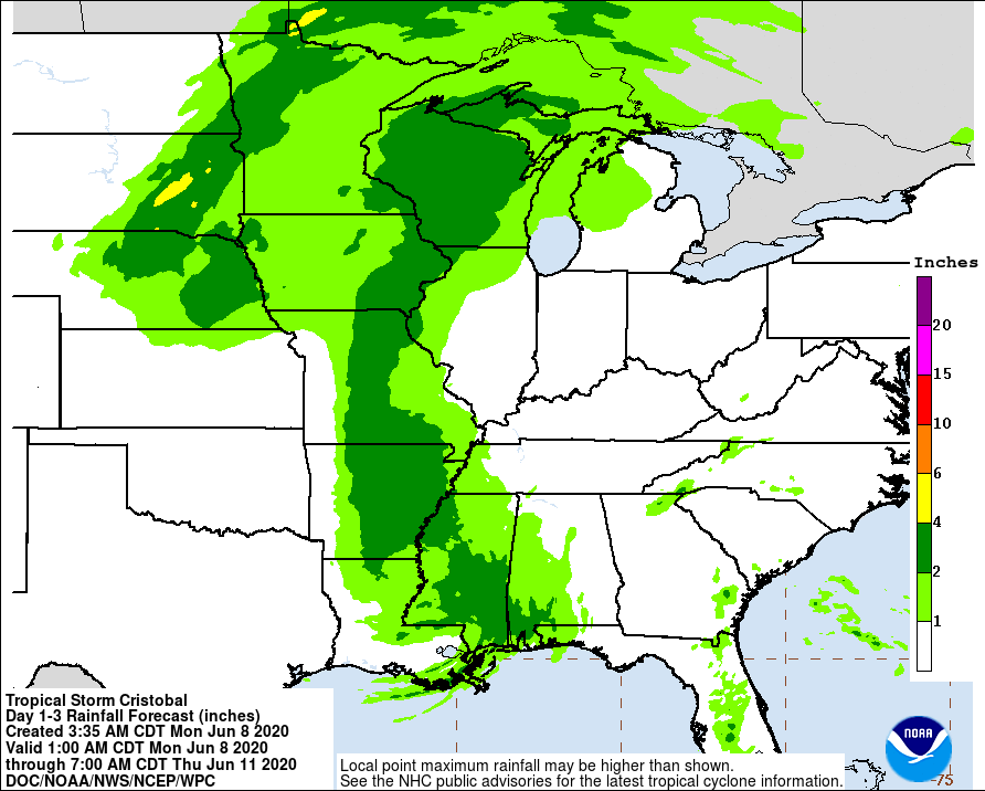
RAINFALL: Cristobal is expected to produce storm total rainfall accumulations of 5 to 10 inches across portions of the central to eastern Gulf Coast into the Lower Mississippi Valley, with isolated amounts to 15 inches. Rainfall totals of 2 to 4 inches with local amounts to 6 inches are expected across portions of the Mid to Upper Mississippi Valley and Northern Plains near and in advance of Cristobal.
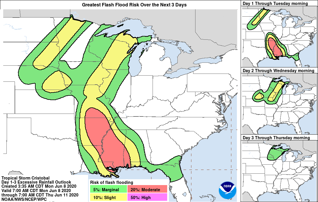
This rainfall has led to flash flooding and forecast widespread river flooding across portions of the central Gulf Coast into the Lower Mississippi Valley. Smaller streams across southeast LA and southern MS have begun to rise and are forecast to crest mid-week. New and renewed significant river flooding is possible across the mid and upper Mississippi Valley.
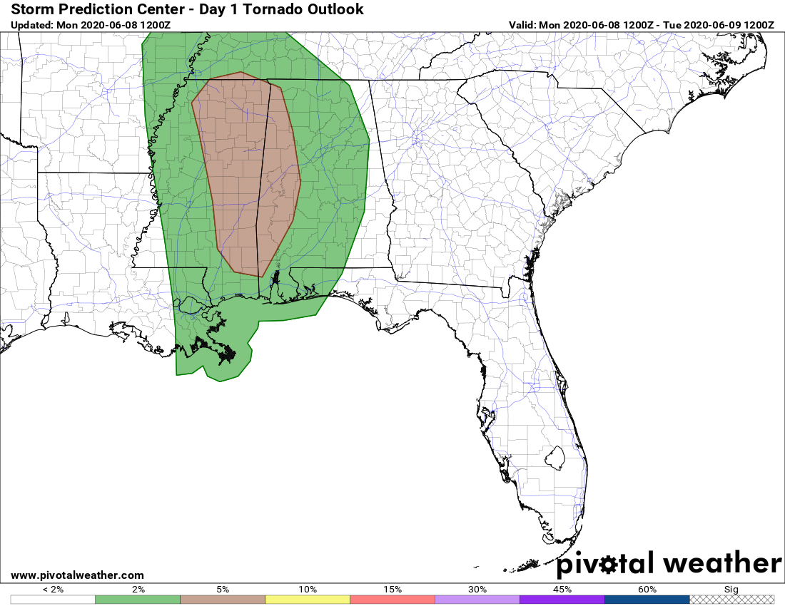
TORNADOES: Isolated tornadoes are possible today and tonight across Mississippi, Alabama, southeastern Louisiana, eastern Arkansas, western Tennessee, and southeastern Missouri.
SURF: Swells generated by Cristobal will affect portions of the northern and eastern Gulf coast through today. These swells are likely to cause life-threatening surf and rip current conditions.
Category: Alabama's Weather, ALL POSTS, Severe Weather, Tropical
About the Author (Author Profile)
Scott Martin is an operational meteorologist, professional graphic artist, musician, husband, and father. Not only is Scott a member of the National Weather Association, but he is also the Central Alabama Chapter of the NWA president. Scott is also the co-founder of Racecast Weather, which provides forecasts for many racing series across the USA. He also supplies forecasts for the BassMaster Elite Series events including the BassMaster Classic.Subscribe
If you enjoyed this article, subscribe to receive more just like it.


