

9:25 Update: More Storms For Alabama Today
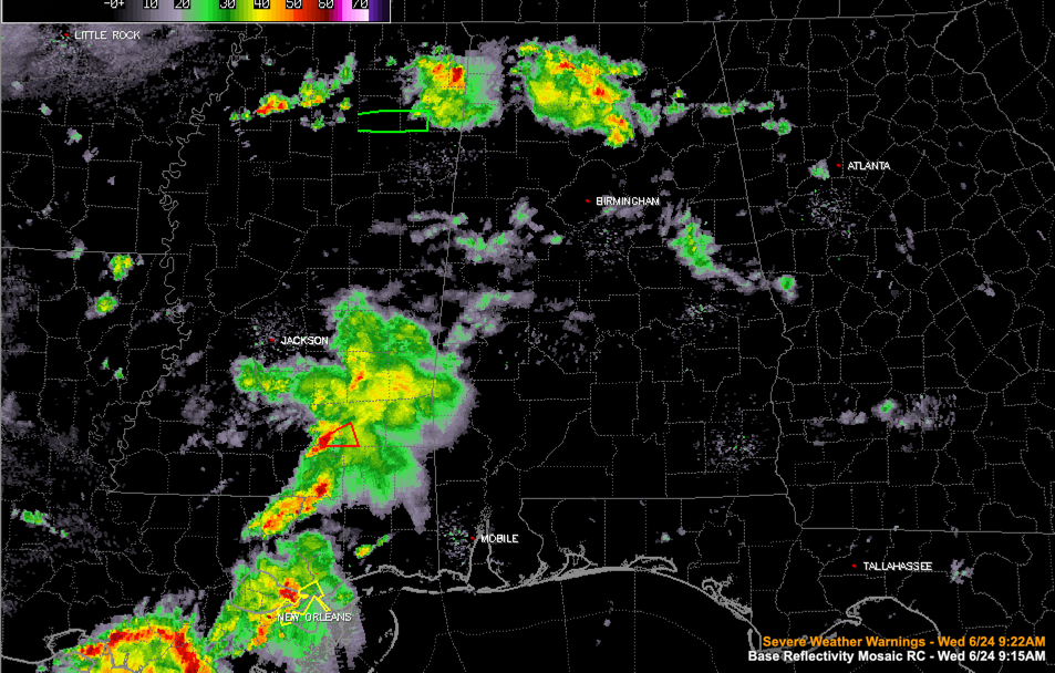
Just after 9 a.m. this morning, showers and thunderstorms are occurring across North Alabama. The heaviest storms are across parts of Morgan and Cullman Counties, where there is a good bit of lightning. They are not severe and are not expected to become so.
Elsewhere across Central Alabama, there are a few light showers.
To the southwest, rain and storms over southern Mississippi and southeastern Louisiana are pushing northeast towards Alabama. There are severe thunderstorm warnings in effect for the New Orleans area. There was a tornado warning for a storm crossing I-59 between Lumberton and Poplarville in southern Mississippi, but it has weakened. A new tornado warning has been issued for a storm headed for Ellisville, just south of Laurel. This activity is associated with a mesoscale convective vortex that will be moving into Alabama later. This feature could intensify with the heating of the day.
Showers and storms are expected to be numerous across Alabama today, especially Central and southern sections, where a few of them could become severe. The SPC does have its lowest level risk (marginal 1/5) outlook posted for areas along and south of I-59 in Alabama. Damaging wind gusts are the main threat. Areas south and west of Montgomery could see a spin-up tornado.
Category: Alabama's Weather, ALL POSTS
About the Author (Author Profile)
Bill Murray is the President of The Weather Factory. He is the site's official weather historian and a weekend forecaster. He also anchors the site's severe weather coverage. Bill Murray is the proud holder of National Weather Association Digital Seal #0001 @wxhistorianSubscribe
If you enjoyed this article, subscribe to receive more just like it.


