A Few Strong Storms Out There at Midday
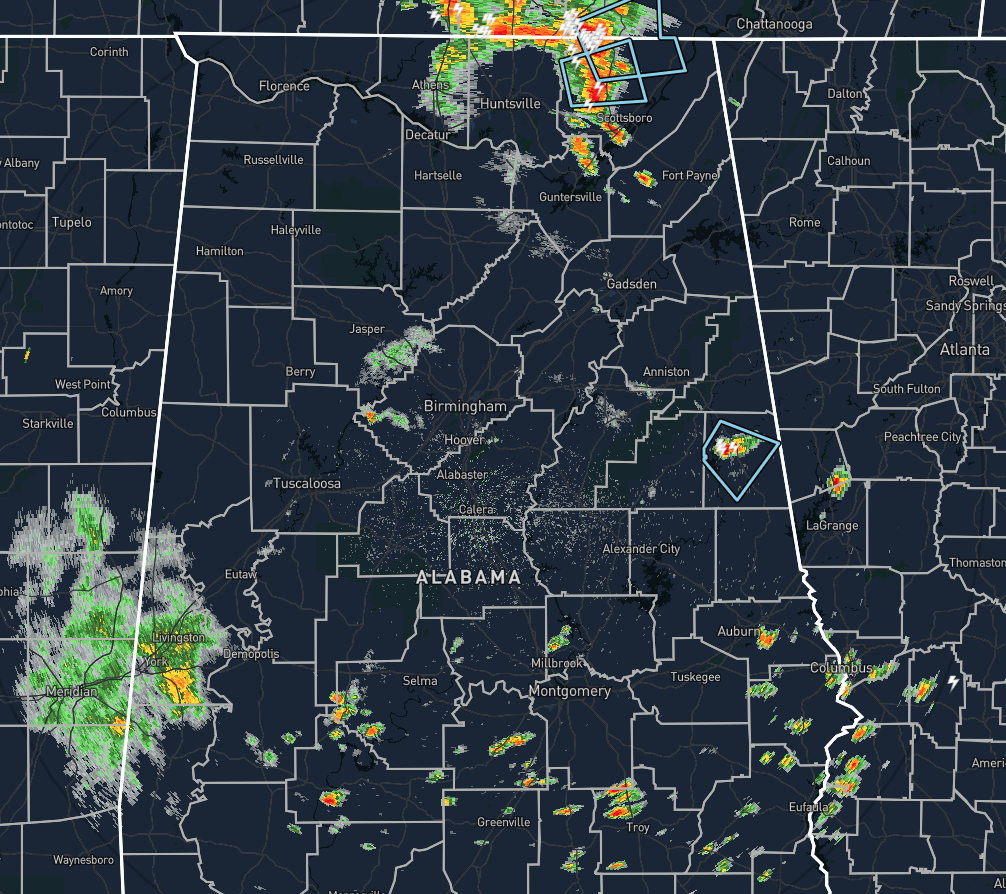
At 11:33 am, We have a few Significant Weather Advisories in effect for stronger storms that are producing very heavy rainfall, dangerous cloud-to-ground lightning, and gusty winds up to and possibly exceeding 40 MPH. Those storms are located over Randolph County in the eastern part of Central Alabama and Jackson County in the northeastern part of North Alabama. A few scattered showers have developed over the extreme southern parts of Central Alabama, but those are strong at the moment.
Temperatures as of the 11:00 am Round-Up were in the upper 70s to the upper 80s. Haleyville was the cool spot at 77 degrees while Troy was the warm spot at 89 degrees. Birmingham was sitting at 83 degrees.
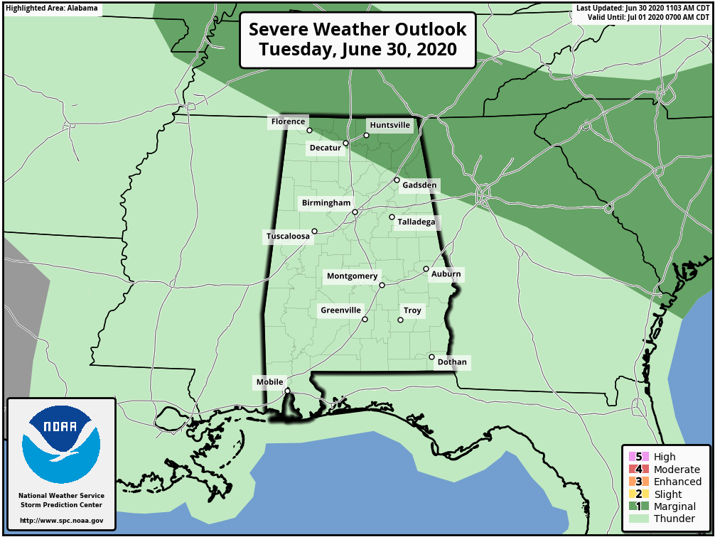
We do have the potential for a few stronger to severe storms during the afternoon and early evening hours over the northern and northeastern parts of the state, and the Storm Prediction Center has a level 1 Marginal Risk up for locations north of a line from Florence to Decatur to Gadsden. Isolated damaging wind gusts up to 60 MPH are possible with any stronger storms. We’ll have a good chance of showers and thunderstorms for locations south of a line from Hamilton to Clanton to Eufaula during the afternoon and evening hours, while showers and storms will be likely for locations north of that line. Afternoon highs will be in the upper 80s to the lower 90s.
The scattered shower and storm activity will mostly diminish during the evening hours, but another round of showers and storms may invade the northwestern parts of the area during the late-night and into the overnight hours. By this time, we will have lost enough instability that storms should not become severe. Overnight lows will be in the lower to mid-70s.
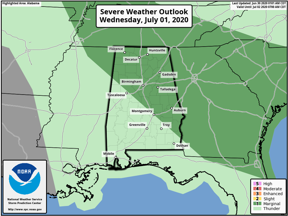
Strong to severe storms will once again be possible mainly during the afternoon and evening hours on Wednesday and the Storm Prediction Center has a level 1 Marginal Risk up for all of North Alabama and for a good portion of Central Alabama… north of a line from Vernon (Lamar Co.) to Prattville (Autauga Co.) to Louisville (Barbour Co.). Isolated damaging winds up to 60 MPH and hail up to golf ball size will be possible. Showers and storms will be likely for the eastern two-thirds of Central Alabama, with just slightly lower chances in the west. Highs will be in the upper 80s to the mid-90s.
Category: Alabama's Weather, ALL POSTS, Severe Weather
About the Author (Author Profile)
Scott Martin is an operational meteorologist, professional graphic artist, musician, husband, and father. Not only is Scott a member of the National Weather Association, but he is also the Central Alabama Chapter of the NWA president. Scott is also the co-founder of Racecast Weather, which provides forecasts for many racing series across the USA. He also supplies forecasts for the BassMaster Elite Series events including the BassMaster Classic.Subscribe
If you enjoyed this article, subscribe to receive more just like it.


