Fay Makes Landfall Close to Atlantic City, New Jersey
FAY MAKES LANDFALL JUST NORTH-NORTHEAST OF ATLANTIC CITY, NEW JERSEY
HEAVY RAINFALL AND GUSTY WINDS MOVING INTO NORTHERN NEW JERSEY, SOUTHEASTERN NEW YORK, AND LONG ISLAND
SUMMARY OF 4:00 PM CDT
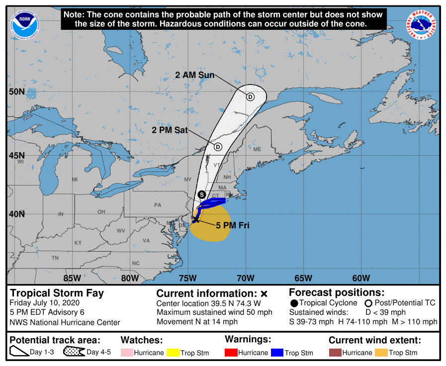
LOCATION: 39.5N 74.3W
ABOUT 10 MI NNE OF ATLANTIC CITY, NEW JERSEY
ABOUT 90 MI S OF NEW YORK CITY, NEW YORK
MAXIMUM SUSTAINED WINDS: 50 MPH
MOVEMENT: N AT 14 MPH
MINIMUM CENTRAL PRESSURE: 998 MB or 29.47 INCHES
WATCHES AND WARNINGS
A Tropical Storm Warning is in effect for…
Great Egg Inlet New Jersey to Watch Hill Rhode Island including
Long Island and Long Island Sound.
FORECAST DISCUSSION
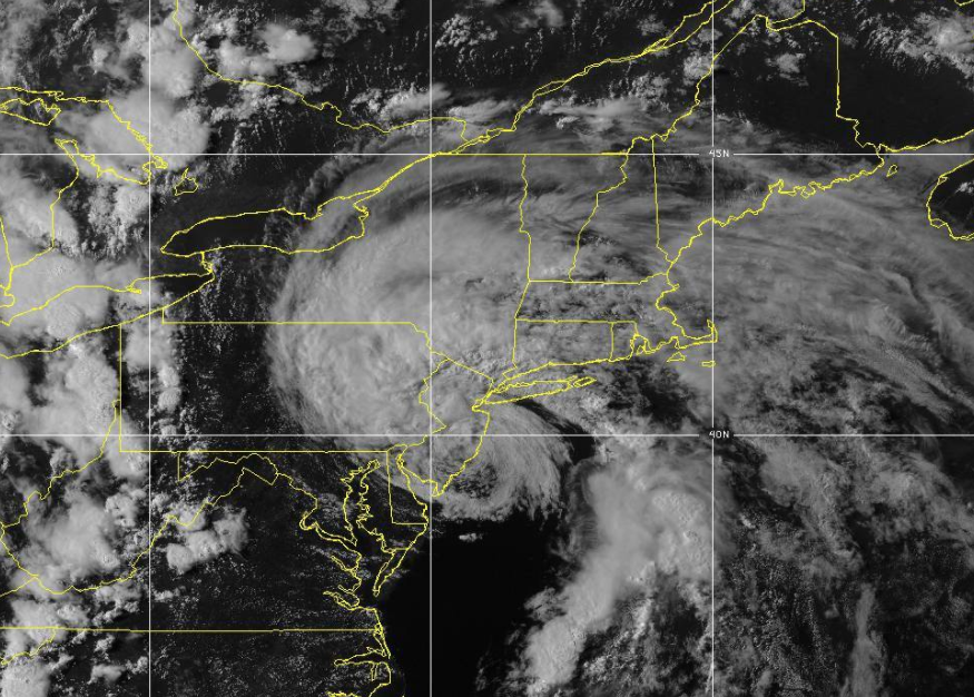
Fay’s structure is looking less tropical this afternoon. While the central circulation is decidedly warm core, it is lacking deep convection and consists entirely of low to mid-level clouds. The deepest convection is found in cloud bands located well east and southeast of the center. The initial intensity is set to 45 kt, with the strongest winds found in a convective band northeast of the center as seen in velocity data from the KOKX WSR-88D. The last fix from the earlier aircraft mission provided a central pressure estimate of 998 MB.
Gradual weakening should occur from here on as the cyclone begins to interact more with land, however, stronger winds are expected to persist over water even after the center moves inland tonight. Fay is shown as a 35-kt tropical storm inland at 12 hours, but those winds are expected to be over water well southeast of the center by that time. On Saturday, Fay should weaken as a post-tropical cyclone and dissipate in 36 to 48 hours.
The initial motion estimate is 010/12 kt. The track forecast reasoning remains unchanged, as Fay will be steered generally northward and north-northeastward until dissipation between a mid-level ridge over the western Atlantic and an approaching shortwave trough moving across the Great Lakes. The new NHC track forecast is close to the previous one and lies near the middle of the guidance envelope.
Users should not place too much emphasis on the exact track of the center of Fay, as heavy rainfall and strong winds will continue to affect areas well away from the cyclone’s center.
KEY MESSAGES
1. Heavy rainfall from northern Delaware and eastern Pennsylvania northeast across New Jersey, southeast New York, and portions of New England may result in flash flooding and urban flooding in areas with poor drainage. While isolated minor flooding is possible, widespread river flooding is not expected.
2. Tropical storm conditions will continue to spread northward across portions of the mid-Atlantic and northeast coast today and tonight, and a Tropical Storm Warning is in effect for the coasts of New Jersey, New York, and Connecticut, including Long Island.
Category: ALL POSTS, Severe Weather, Tropical
About the Author (Author Profile)
Scott Martin is an operational meteorologist, professional graphic artist, musician, husband, and father. Not only is Scott a member of the National Weather Association, but he is also the Central Alabama Chapter of the NWA president. Scott is also the co-founder of Racecast Weather, which provides forecasts for many racing series across the USA. He also supplies forecasts for the BassMaster Elite Series events including the BassMaster Classic.Subscribe
If you enjoyed this article, subscribe to receive more just like it.


