Weather Xtreme: Strong Storms Today, Heat is the Story this Week
You could barely find a cloud in the sky across Alabama on Saturday and the result was a hot afternoon. It was a “dry heat” with lower dewpoints behind a front that had settled over South Alabama, but still hot with highs in the lower and middle 90s. We will deal with a threat for severe weather today and then some of the hottest temperatures of the year in the week ahead.
ON THE WEATHER MAPS: We find a sprawling upper-level ridge over the southwestern United States from California to Texas. There is a trough over the Pacific Northwest and another over the eastern third of the country. A fairly well-defined shortwave trough is diving through the Midwest this morning, with lots of energy coming into Arkansas. That is going to be Alabama’s next weathermaker.
TENNESSEE STORMS: That disturbance coming at us from the northwest this morning has triggered a complex of showers and storms that will push through North and North Alabama this morning into the afternoon. The storms will have lots of lightning, heavy rain, and gusty winds before they diminish. Some places could pick up over an inch of rain from the storms. The SPC does have a “marginal risk”, 1/5 on their scale, for severe storms for today for much of Alabama.
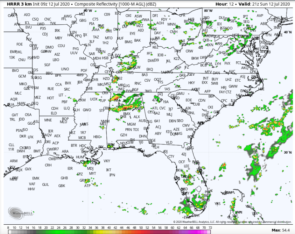
HRRR depiction of what the radar might look like at 4 p.m. today
AFTERNOON STORMS: We have been hanging our hat on the fact that afternoon storms could be strong to severe, but that may be hindered by cloud cover and lower temperatures from the morning activity. But additional storms are expected to form on the western periphery of the where the morning activity traveled, and those might have enough instability to become strong. We will be watching for damaging wind gusts as the main threat.
HIGHS TODAY: Afternoon readings may not get out of the 80s over North Alabama, but should reach 90F in the I-20 Corridor, with mid and upper 90s over South Central Alabama. Readings will be approaching the heat advisory category over southwestern sections of Central Alabama later today in places like Demopis and Sema. Everyone drops back in the 870s overnight tonight.
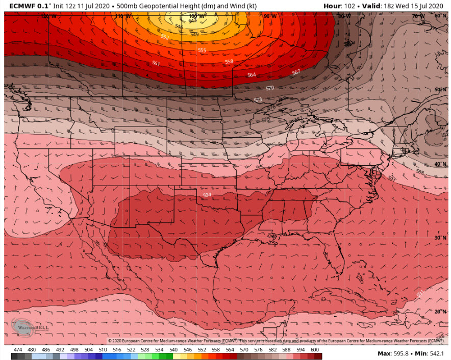
THE WEEK AHEAD: The big heat ridge over the southwestern United States will, unfortunately, expand eastward across the southern tier of states in the week ahead, and this means that the mercury will be rising across Alabama and the South. Showers and storms will be hard to find by Monday, and that should be the case through midweek. Highs on Monday and Tuesday will be in the lower 90s, with middle and upper 90s by Wednesday, Thursday, and Friday. Middle 90s will prevail into the weekend. Heat index values will definitely be approaching 100-105F by Wednesday and Thursday and heat advisories may be in order. There are hints from the GFS that a few showers and storms will start to show back up by Thursday and Friday and into the weekend. We will keep our fingers crossed. Highs over the weekend will still be hot, in the middle 90s.
RAIN TOTALS: The GFS ensemble members average out to around 2 inches at Birmingham over the two week period. That’s about normal but won’t keep up with our needs with that kind of heat of course. If the GFS control is right, some spots will definitely get more by the end of next weekend. Again, fingers crossed.
TROPICS: It’s hard to believe that we already have six named storms in the books in the Atlantic Hurricane Season. It’s the earliest we have ever gotten to the sixth storm, besting even the busy 2005 season, in which we had just said goodbye to Dennis and birthed Emily. Nothing threatening to become a tropical cyclone in the short term over the Atlantic basin. We will be watching tropical waves rolling off the coast over the next few weeks as they are already quite strong and it will make for an interesting August – October period in the Atlantic basin.
GULF COAST WEATHER: Showers and storms will be few and far between along the beautiful beaches of Alabama and Northwest Florida until next weekend when a tropical wave will arrive from the Caribbean. Lows will be in the middle 70s and highs in the lower 90s all this week. Water temperatures are in the lower 80s. The rip current risk will be low all week with surf heights running 1-2 feet.
DANCING WITH THE STATS: One of my favorite places in America is Alamosa, Colorado. Located at over 7,500 in the San Luis Valley southwest of Alamosa, surrounded on three sides by high mountains, the beautiful town is often the nation’s icebox. In fact, between 1195 and 2005, it was the coldest spot in the nation 142 times, the fifth most of any location. At 447 pm Friday, the temp in Alamosa hit 92F. This sets a new record high temp for July 10th, breaking the old record of 91F, set in 2003. This means that Alamosa set a new record HIGH and a new record LOW on the SAME DAY, when the temp fell to 37F that same morning!
WEATHERBRAINS: We had a great time this week visiting with Jimmy Hall of Wet Willie. His song “Keep on Smilin’” went to number 10 on the pop charts in 1974. We were also joined by the Meteorologist in Charge of the National Weather Service in Juneau, Alaska, Jeff Garmon. Check out the show at www.WeatherBrains.com. You can also subscribe on iTunes. You can watch the show live at http://live.bigbrainsmedia.com/ You can see the show on the James Spann 24×7 weather channel on cable or directly over the air on the dot 2 feed.
ON THIS DATE IN 1980: The death toll in Alabama’s crippling heat wave climbed to four, including two people in Birmingham and two in Mobile. A 51-year-old Birmingham man died of heatstroke. It had been 90F or hotter in Birmingham for 12 straight days. The high that Friday afternoon at the Birmingham Airport topped out at 102F, the second straight day of 100+ degree heat. Forecasters called for the Saturday high to reach 104F. They would be right. Follow my weather history tweets on Twitter. I am @wxhistorian at Twitter.com.
Category: Alabama's Weather, ALL POSTS
About the Author (Author Profile)
Bill Murray is the President of The Weather Factory. He is the site's official weather historian and a weekend forecaster. He also anchors the site's severe weather coverage. Bill Murray is the proud holder of National Weather Association Digital Seal #0001 @wxhistorianSubscribe
If you enjoyed this article, subscribe to receive more just like it.


